
The ambitious plan to protect Northern California’s Plumas National Forest from wildfires
A white-headed woodpecker stirs the dawn quiet, hammering at a patch of charred bark stretching 15 feet up the trunk of a ponderosa pine. The first streaks of sun light the tree’s green crown, sending beams across this grove of healthy conifers. The marks of the 2021 Dixie Fire are everywhere. Several blackened trees lie toppled among the pale blossoms of deer brush and the spikes of snow plants, their crimson faded to dusky coral. Flames raged through neighboring forests, exploding the tops of trees, flinging sparks down the mountainside until, on August 4, 2021, the fire itself reached the valley below and Greenville, 90 miles north of Lake Oroville. It took less than 30 minutes to destroy a town of 1,000 residents. Yet this stand at Round Valley Reservoir survived. Years earlier, U.S. Forest Service crews had removed the brush and smaller trees, reducing the most flammable vegetation. Then they set fires, burning what was left on the ground in slow-moving spurts of flame. When Dixie arrived, the same fire that melted cars and torched 800 homes hit this stand and dropped to the ground. Here Dixie was tame, a docile blaze meandering across the forest floor with only occasional licks up the trunks of trees, says Ryan Bauer, Plumas National Forest fuels manager for the past 18 years. If only there had been more active forest management like this, laments Bauer. Instead of 100-acre patches, “if we had burned 10,000-acre patches, we’d have 10,000-acre patches of surviving forest. We just never did,” says Bauer, who recently retired and is now working with a nonprofit to adapt communities to fire. Two-thirds of the Plumas National Forest has burned in the last seven years, an area twice the size of San Francisco Bay. The fires have sent smoke charging down the Feather River Canyon, across the Central Valley, and into the San Francisco Bay Area, turning the sky burnt orange. Each fire has taken a toll on the watershed that provides drinking water to over 27 million people in California. With every blaze, habitat for deer, bald eagles, and four of California’s 10 wolf packs hangs in the balance. Read Next Wildfire smoke could soon kill 71,000 Americans every year Matt Simon The rest of the Plumas Forest is still green but far too crowded, with trees six to seven times as dense as in the past, according to a 2022 study led by prominent fire scientist Malcolm North. As forests dry each summer, a process exacerbated by climate change, vegetation becomes vulnerable to the least spark, poised to rage into the catastrophic wildfires experts predict are inevitable without a dramatic increase in active forest management. If the Plumas burns, the 8,000 people who live in towns like Quincy, Graeagle, and Portola are in jeopardy—at risk of joining the thousands of us forced to evacuate Paradise, Greenville, and other Plumas communities destroyed by recent wildfires. The forest also faces an existential risk, says Michael Hall, manager of the Feather River Resource Conservation District. Because forests in the Sierra Nevada have evolved with fire, they depend on its power to clear out overcrowded trees and let in nurturing bursts of sunlight, to spur new growth. Black-backed woodpeckers, morels, grasses, ferns, and wildflowers all rely on periodic wildfires. A century of fire suppression has stymied this natural succession, creating overcrowded and decadent stands that have fueled the recent sequence of megafires. If we don’t deal with the threat such fires pose, the soil and seed banks that replenish forests will be destroyed, the trees replaced by shrubs and snags, Hall says. Some ponderosa and red fir stands will convert to oak and brush. Without active management, those will burn, too. “And then we’ve lost a forest,” he says. It’s a nightmare scenario that has jolted Forest Service officials into action. Urged on by scientists, the Forest Service, and other natural resource agencies, Plumas Forest officials have launched a plan for a dramatic change in forest management. To mount it, they are using chain saws, drip torches, and an array of gigantic machines that include masticators, feller bunchers, grapples, and hot saws. The goal is to thin, log, and intentionally burn what experts say are unnaturally fire-prone forests. If their work can stay ahead of stand-converting flames, they hope to leave a vast swath of trees resilient to future fires. The project, which targets 285,000 acres of forest, is called Plumas Community Protection, and Congress in 2023 gave the Forest Service $274 million to carry it out. This plan is visionary and ambitious but untested in scale. Its success depends on rapid accomplishment by a bureaucracy seldom known to be nimble, and now in the hands of an administration that has laid off thousands of workers and frozen millions of dollars of federal funds. Despite the high stakes, Forest Service officials have held few public meetings, refused to provide basic details of the project with reporters, and declined to review a summary of our findings. Bay Nature and The Plumas Sun reported largely without the help of federal officials, including public information officers who said they feared doing their jobs would end them. Instead, we interviewed 47 forest experts—agencies, nonprofit organizations, and community leaders—and mined public documents to piece together a picture of the Plumas Community Protection project so far. These interviews have made clear that the funding, unimaginable five years ago, has been largely spent or obligated. Yet little on-the-ground work has been accomplished in the woods. The plan is already foundering. Hail Mary plan Almost all of us who live in Plumas County can recite the recent fire sequence in chronological order starting in 2017: the Minerva, Camp, Walker, North Complex, Dixie, Beckwourth Complex, Park. . . . Each name triggers a wave of anxiety. It was the 2021 Dixie Fire that delivered the harshest blow, devastating the communities of Canyon Dam, Greenville, Indian Falls, and Warner Valley as it roared up the Feather River Canyon and on through Lassen Volcanic National Park to Hat Creek. When high winds relented and crews quelled the flames that October, the Dixie Fire had burned nearly one million acres in California’s largest single fire in recorded history. For those who evacuated, who lost homes, offices, and entire businesses, time is forever divided into before and after, pre-fire and post. In the months that followed, stunned Plumas Forest officials grappled with an uncomfortable reality. For decades they had been marking trees to cut, administering timber sales that met the board-footage targets set by officials in Washington, D.C., and putting out every fire they could. By the 1990s, they had realized this management was contributing to larger and more intense wildfires. In response, they had developed a network of fuel breaks—modest linear patches cleared of vegetation—to slow the spread of fire. Reporting by Tanvi Dutta Gupta / Illustration by Kelly Murphy The patch near Round Valley was among the few successful fuel breaks on the Plumas Forest. The Dixie Fire overwhelmed most of the others, along with a handful of related projects. “They just got bowled over by this fire that was happening at this scale we’d never seen before,” says Angela Avery, executive director of Sierra Nevada Conservancy, a state-funded conservation organization. The horrendous damage Dixie caused made it clear that nothing was working to protect the Plumas Forest and its rural communities. “We threw everything we had at that fire but there was nothing we could do to stop it,” says Bauer, the former Plumas National Forest fuels manager. Bauer, a 1994 graduate of Portola High School in eastern Plumas County, first became intrigued by the role of fire in forest ecosystems in a high school forestry class. Returning fire to landscapes that evolved with it has been his focus during most of his 31-year Forest Service career. As the Dixie smoke settled, Bauer saw an opportunity. He began to develop new plans with regional Fire Safe Councils and community wildfire preparedness groups. They focused on the towns within the Plumas Forest that wildfire had not yet burned. Their plans were aimed at making communities safer and forest stands more resilient to drought, insects, and other climate-driven disturbances. Community protection was the first priority, forest resilience the second. Ideas included up to mile-wide buffer zones around every area where communities bumped up against forests, known as the wildland urban interface (WUI). Bauer’s back-of-the-napkin strategies evolved into the plans that formed the management basis for the community protection plan. The long-term goal is preparing these unburned forests for future fires to amble along the forest floor, clearing out the vegetation that can build into stand-destroying wildfires. The plans expand WUI buffer areas and significantly increase the acreage designated for thinning and logging. Crucially, the plans emphasize the importance of intentional fires set routinely throughout the forest. No thinning, no commercial logging project is complete until the acreage has been intentionally burned, Bauer says. Bauer and his Fire Safe colleagues mapped 300,000 acres where dense brush and overcrowded trees posed a hazard to communities and natural resources. Forest officials launched biological, archaeological, and watershed surveys and started to streamline the environmental analyses they would eventually need. Forest planners often work ahead of funding, but this was a 300,000-acre plan with no assurance of approval or money. “It was a bit of a Hail Mary,” Bauer says. “We take risks sometimes, but mostly safer than this one.” This Hail Mary aimed to save 41 rural communities and the national forest in the immediate path of a potential wildfire all too real in the post-Dixie world. A whopping $274 million The ferocity of the Dixie and other megafires in 2020 and 2021 shocked Forest Service officials in Washington, D.C. In 2022, they announced a wildfire crisis strategy designating 45 million acres, mostly in the West, for attention as particularly high-risk “firesheds.” Congress allocated $3.2 billion in the Bipartisan Infrastructure Law (BIL) and Inflation Reduction Act (IRA) to make them safer. In January 2023, the agency added the Plumas National Forest’s 285,000 acres to the strategy. The astonishing $273,930,000 investment underscored the urgency felt from Quincy to the nation’s capital. The Plumas Forest funding is about 20 percent of the $1.4 billion in federal BIL and IRA spending for nature in Northern California that Bay Nature has tracked in its Wild Billions reporting project, and it is the largest single allocation by far. A commitment to forest health in such a large landscape with that level of funding is monumental, says Chris Daunt, a Portola resident with the Mule Deer Foundation, which received $14 million for on-the-ground treatments—“a once-in-a-lifetime opportunity.” Work quickly shifted to identifying specific geographic areas to begin the thinning and logging that would prepare the way for beneficial fires that protect communities. Some work already begun around Quincy, the county seat, was rolled into the Community Protection project. The next priority became Portola, Graeagle, and a string of small towns along Highway 70, where planning was already underway. Forest officials allocated $85 million from the federal fund to Sierra Tahoe Environmental Management, a logging company based in Loyalton formed around the time the well-funded Plumas plan was announced. STEM is tasked with removing hazardous trees across 70,000 acres, selecting those large enough to log for commercial sale, and eventually applying intentional fire. The nonprofit Missoula, Montana–based National Forest Foundation (NFF) was allocated $98 million to complete similar work on 70,000 acres in the valley surrounding Quincy and Mohawk Valley to the east. Bigger, faster The sheer size of the Plumas Forest projects is unprecedented. The two 70,000-acre projects are each more than seven times bigger than most previous Plumas contracts and on a much larger scale than has been done in California. It’s the level we need to be working toward, says Jason Moghaddas, a Quincy-based forester, fire ecologist, and geographic analyst who is familiar with the Plumas National Forest. Size is actually the point, says Avery of the Sierra Nevada Conservancy. Motivated by how much bigger fires have gotten, the Conservancy has invested in landscape-scale projects. “If a megafire or a million-acre fire comes through, we have more opportunity to stand against it, for the treatments to work,” she says. Bauer and other Plumas Forest officials planned thinning projects that leaped from 5,000 acres to 50,000 and prescribed burns that would cover most of the Plumas Community Protection landscape. The urgency of imminent wildfire caused the Plumas Forest officials to pare down the environmental analyses required by the National Environmental Policy Act. Instead of conducting full environmental impact statements, with scrutiny of cumulative impacts and years-long public comment periods, officials used less rigorous environmental assessments. Work on at least 70,000 acres was fast-tracked under emergency declarations, which eliminate public objections. NEPA processes that would normally take as long as seven years took an average of about 20 months. Read Next Who pays for wildfire damage? In the West, utilities are shifting the risk to customers. Will Peischel This tack brought a few critics—most significantly, two environmental groups that sued the Forest Service for failing to take a “more than perfunctory” look at environmental consequences. Plumas National Forest officials temporarily withdrew their approval for treating more than half the target landscape’s area—delaying implementation for over a year to revise their environmental analysis. It was just released July 1. But nearly all of the 47 people interviewed argued that cutting procedural corners is justified by the looming threat of disastrous fire. The challenge is, “can we work fast enough and do the work well enough to stave off some of the catastrophic outcomes we are seeing,” says Jonathan Kusel, executive director of the Sierra Institute for Community and Environment, whose organization has helped with environmental reviews for the Plumas Forest. Recent science supports both the size and urgency of the Plumas projects, according to Scott Stephens, professor of fire science at UC Berkeley. Some are calling for even more work on even larger landscapes. “If anything, the Plumas Community Protection project doesn’t treat enough acres,” Hall wrote with others in a published commentary. What’s done Driving around Plumas County, where the federal government manages 90 percent of the land, roads seem to go through one mile of green forest for every two miles of charred stands, their specters sometimes reaching to the horizon. Halfway between Quincy and the remote mining town of La Porte, a green forest of red fir and butterscotch-scented Jeffrey pines plunges down the mountain to the Middle Fork of the Feather River. Only the high-pitched call of a Townsend’s solitaire interrupts the muffled cascade a thousand feet below. Sugar pines dangle their foot-long cones on surrounding slopes so thick with seedlings and saplings a California black bear would be challenged to forage among them. This is some of the unnaturally dense forest slated for thinning, logging, and intentional burning. Two years after Congress approved the $274 million, work in the woods has been slow to advance. Progress toward the goal of treating 74,000 acres in 2023, with a total of 185,000 acres in subsequent years, is incremental. Some work has been done. In areas around Quincy and Meadow Valley, and near communities along Highway 70 toward Portola, mastication machines have been chewing brush and small trees into wood chips and spitting them back onto the landscape. Crews are also using chain saws and other machines to thin forests. These are steps preliminary to commercial logging, which has not started. The Forest Service’s annual reports say 49,496 acres of Plumas Forest were treated in 2023 and 5,400 acres in 2024, about one-fifth of the goal. But it’s unclear how much safer the forest is. The reports do not say whether the treatment was thinning, logging, or intentional burning, nor where the activity occurred. Scientists and forest managers across the West have been debating for years how to measure forest resilience and community protection. Acreage is not reliable, says Bauer. A better measure would count an acre as treated when all the on-the-ground work is done, says Eric Edwards, whose research at UC Davis focuses on environmental and agricultural economics. For all the wildfire crisis strategy’s hype of intentional burning and its protective benefits for both forests and communities, the Plumas plan is vague on acreage goals and enforcing the contractors’ burn objectives. It identifies all 285,000 acres for intentional fire, says Bauer. But unlike with thinning and logging, operators are not tied to burn goals. “It’s always a soft commitment,” Bauer says. Plumas Forest officials have reported 2,543 acres burned since October. Almost all of it was burning piles of branches and brush, not the essential low-intensity intentional fires that sweep across the forest floor. Those intentional broadcast burns total about 2,500 acres, Bay Nature and The Plumas Sun estimate, using Forest Service data with help from experts. That’s just under 1 percent of the target landscape. Read Next Two years after a wildfire took everything, Maui homeowners are facing a new threat: Foreclosure Anita Hofschneider In reports on the nationwide wildfire crisis strategy, the Forest Service has cited challenges to implementation, including inflated costs, a lack of timber market for small-diameter wood, employee housing costs, uncompetitive pay, and limited on-the-ground capacity. Little of the information about progress on the Plumas Community Protection projects has come from Plumas Forest officials, who have given short shrift to reporters’ questions since late January. Calls to the Plumas Forest supervisor’s office have gone unreturned, sometimes careening in bizarre redirects that include a scratchy recording of the Smokey Bear song. Reporters’ written questions, submitted in February to the Forest Service’s public affairs office in Washington, D.C., have gone unanswered. The Trump administration has blocked press access to agency scientists and taken down the interactive map that once documented project progress. The only interview granted since late January was a half hour, in August, on how to use agency data. Links to websites available in January now post “page not found” or, more cynically, “Looks like you hit the end of the trail.” Some Plumas residents say the Forest Service has shirked its obligation to keep the public informed. John Sheehan, who has paid close attention to Plumas National Forest issues since 1992, was dismayed by knowing “next to nothing” about the Community Protection plan, he says. “When the government’s going to do something this big and this close to communities, it needs to be in touch with the people affected. The Plumas Forest just isn’t.” Josh Hart, a spokesperson for Feather River Action!, one of the plaintiffs in the lawsuit filed by environmental groups, complains about the dearth of public information for “the most significant plans for the Plumas National Forest ever in history.” The agency has provided no accounting of how it has spent the $274 million. Public records and interviews with contractors reveal that around $202 million has been allocated in contracts for thinning and logging. Another $5 million went to prescribed burning, Bauer says. The Great Basin Institute received approximately $2 million for wildlife surveys. Approximately $50 million went to environmental analyses. That leaves $15 million unaccounted for. Some went directly to salaries, says Bauer. Most of the rest likely went to planning, he says. “That funding source is gone.” The agency acknowledged in a 2025 national report that it had run through most of its BIL and IRA money. “Fully realizing the vision laid out by the Wildfire Crisis Strategy will require further, sustained investments,” the report says. Hamstrung Two full years since the launch of the Plumas Community Protection plan, the Plumas Forest’s hamstrung capacity raises questions about its ability to execute its own plan. Recent Trump administration layoffs cap years of reduced staffing. The Plumas Forest supervisor position was vacant for over a year. A merry-go-round of vacancies and short-term appointments often leaves partners and contractors in limbo, waiting for decisions to allow their work to proceed, says Jim Wilcox, a Plumas Corporation senior adviser who has worked on Forest Service restoration contracts for 35 years. “The delays drive everyone crazy.” Other agencies and private companies are filling some of the gaps, which is part of the national strategy to address the wildfire crisis. They have done most of the required environmental analyses and are slated for much of the on-the-ground project work. The Forest Service has always used non-agency partners to do logging and burning, Moghaddas says, but with giant 70,000-acre units, the partnerships are larger and more complex. “The Forest Service can’t do it alone,” he says. Avery calls it a cultural shift: “I have seen an evolution in the Forest Service’s willingness to work with partners, which I thought was a good thing in response to a tragedy.” Read Next First came the wildfire. Then came the scams. Naveena Sadasivam The shift away from federal oversight of national forest land, though, worries Hall. Forest Service crews have generally been composed of people who care about protecting and preserving public lands, he says. “I love the idea of public land and having so much of it available . . . If we don’t have someone obligated to steward it—and that’s the Forest Service folks—we’re all in trouble.” While STEM is a company of experienced loggers and NFF has demonstrated dedication to national forest health, these are new ventures for each organization. Ivy Kostick, NFF’s forester for the 70,000-acre project, is breaking it down into manageable pieces, she says: “How do you eat an elephant? One bite at a time?” Moment of opportunity Now, four years after the Dixie Fire, the ambitious Plumas Community Protection plan is still more promise than on-the-ground reality. Because funding has already been obligated, the major work should eventually proceed, says Jake Blaufuss, a lifelong local and Quincy-based forester for American Forest Resource Council, a trade association that advocates for sustainable forests. Commercial logging will generate revenue that can be reinvested in prescribed burning and other remaining work, Blaufuss says. Jeff Holland, a spokesperson for STEM, says 2026 will bring enough activity “where people will actually see the difference.” For Bauer, the plan’s $274 million bought something essential: environmental analyses. While the Forest Service provided no financial details, partners close to the project confirmed that some of the federal funds went to the biological surveys, stream assessments, archaeological reviews, and timber stand counts required under NEPA. Today, most of the Plumas Community Protection landscape is covered by an approved plan. While currently there’s not a lot of actual activity, when it begins, Blaufuss says, these documents will “allow the Forest Service to be nimble.” Bauer measures the scale of success by the scale of prescribed fire. The goal for both forest resilience and community protection is to follow thinning and logging with burning; it is the goal for the Plumas Community Protection project. What haunts Bauer are the places around Greenville where pre-Dixie plans called for aggressive thinning followed by prescribed fire. Most never saw a chain saw or a drip torch, and most were totally incinerated when Dixie blazed through. “We just didn’t get to them,” Bauer says. If the Plumas Community Protection project does not complete the plan for prescribed burning, “it’s essentially a roulette scenario,” he says. And so far it hasn’t. What the plan has done is to advance the understanding that fire is essential for forest resilience and community safety. Forest managers are thinking creatively about how to achieve that. The conversation about forest management is shifting. Fire rejuvenates forest ecosystems. While the Dixie Fire’s toll on the Plumas and its communities has been horrific, it leaves them poised for renewal—like silver lupines waiting in the seed bank to burst into flower. If the Plumas Forest project can gain additional funding and muster sufficient political will, the grand plan to protect all that did not burn may advance. “We know we need wholesale change in the way we’re managing the forest,” says Blaufuss. “This is our chance.” Tanvi Dutta Gupta and Anushuya Thapa contributed reporting. This article was supported by the March Conservation Fund. This story was originally published by Grist with the headline The ambitious plan to protect Northern California’s Plumas National Forest from wildfires on Oct 7, 2025.
To shield the forest and its communities from the next megafire, the Forest Service plans to burn it — intentionally.
A white-headed woodpecker stirs the dawn quiet, hammering at a patch of charred bark stretching 15 feet up the trunk of a ponderosa pine. The first streaks of sun light the tree’s green crown, sending beams across this grove of healthy conifers. The marks of the 2021 Dixie Fire are everywhere. Several blackened trees lie toppled among the pale blossoms of deer brush and the spikes of snow plants, their crimson faded to dusky coral.
Flames raged through neighboring forests, exploding the tops of trees, flinging sparks down the mountainside until, on August 4, 2021, the fire itself reached the valley below and Greenville, 90 miles north of Lake Oroville. It took less than 30 minutes to destroy a town of 1,000 residents. Yet this stand at Round Valley Reservoir survived.
Years earlier, U.S. Forest Service crews had removed the brush and smaller trees, reducing the most flammable vegetation. Then they set fires, burning what was left on the ground in slow-moving spurts of flame. When Dixie arrived, the same fire that melted cars and torched 800 homes hit this stand and dropped to the ground. Here Dixie was tame, a docile blaze meandering across the forest floor with only occasional licks up the trunks of trees, says Ryan Bauer, Plumas National Forest fuels manager for the past 18 years.
If only there had been more active forest management like this, laments Bauer. Instead of 100-acre patches, “if we had burned 10,000-acre patches, we’d have 10,000-acre patches of surviving forest. We just never did,” says Bauer, who recently retired and is now working with a nonprofit to adapt communities to fire.
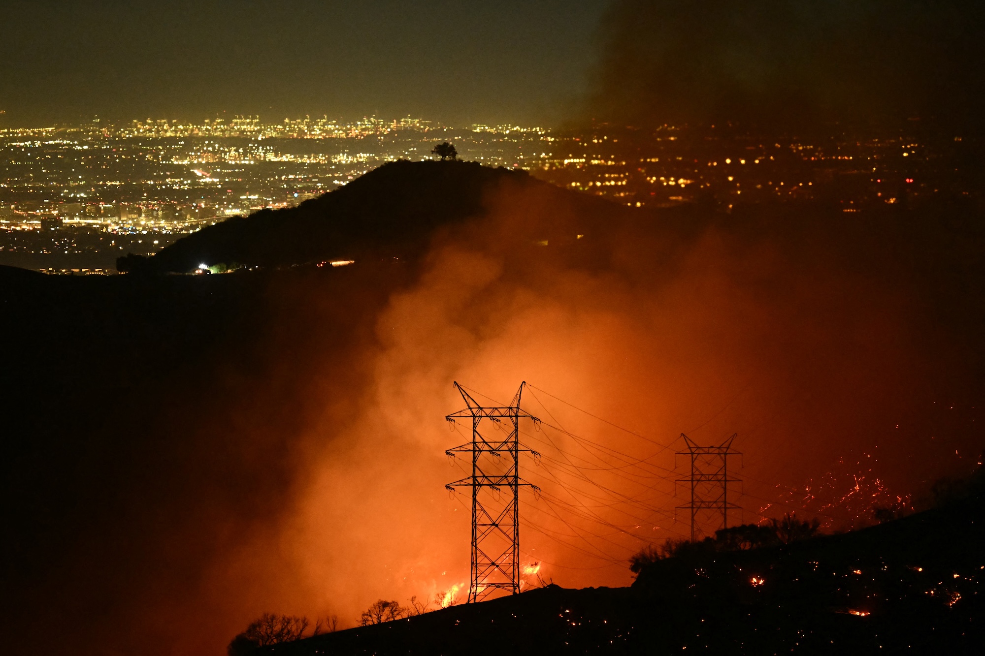
Two-thirds of the Plumas National Forest has burned in the last seven years, an area twice the size of San Francisco Bay. The fires have sent smoke charging down the Feather River Canyon, across the Central Valley, and into the San Francisco Bay Area, turning the sky burnt orange. Each fire has taken a toll on the watershed that provides drinking water to over 27 million people in California. With every blaze, habitat for deer, bald eagles, and four of California’s 10 wolf packs hangs in the balance.

The rest of the Plumas Forest is still green but far too crowded, with trees six to seven times as dense as in the past, according to a 2022 study led by prominent fire scientist Malcolm North. As forests dry each summer, a process exacerbated by climate change, vegetation becomes vulnerable to the least spark, poised to rage into the catastrophic wildfires experts predict are inevitable without a dramatic increase in active forest management. If the Plumas burns, the 8,000 people who live in towns like Quincy, Graeagle, and Portola are in jeopardy—at risk of joining the thousands of us forced to evacuate Paradise, Greenville, and other Plumas communities destroyed by recent wildfires.
The forest also faces an existential risk, says Michael Hall, manager of the Feather River Resource Conservation District. Because forests in the Sierra Nevada have evolved with fire, they depend on its power to clear out overcrowded trees and let in nurturing bursts of sunlight, to spur new growth. Black-backed woodpeckers, morels, grasses, ferns, and wildflowers all rely on periodic wildfires. A century of fire suppression has stymied this natural succession, creating overcrowded and decadent stands that have fueled the recent sequence of megafires. If we don’t deal with the threat such fires pose, the soil and seed banks that replenish forests will be destroyed, the trees replaced by shrubs and snags, Hall says. Some ponderosa and red fir stands will convert to oak and brush. Without active management, those will burn, too. “And then we’ve lost a forest,” he says. It’s a nightmare scenario that has jolted Forest Service officials into action.
Urged on by scientists, the Forest Service, and other natural resource agencies, Plumas Forest officials have launched a plan for a dramatic change in forest management. To mount it, they are using chain saws, drip torches, and an array of gigantic machines that include masticators, feller bunchers, grapples, and hot saws. The goal is to thin, log, and intentionally burn what experts say are unnaturally fire-prone forests. If their work can stay ahead of stand-converting flames, they hope to leave a vast swath of trees resilient to future fires. The project, which targets 285,000 acres of forest, is called Plumas Community Protection, and Congress in 2023 gave the Forest Service $274 million to carry it out.
This plan is visionary and ambitious but untested in scale. Its success depends on rapid accomplishment by a bureaucracy seldom known to be nimble, and now in the hands of an administration that has laid off thousands of workers and frozen millions of dollars of federal funds.
Despite the high stakes, Forest Service officials have held few public meetings, refused to provide basic details of the project with reporters, and declined to review a summary of our findings. Bay Nature and The Plumas Sun reported largely without the help of federal officials, including public information officers who said they feared doing their jobs would end them. Instead, we interviewed 47 forest experts—agencies, nonprofit organizations, and community leaders—and mined public documents to piece together a picture of the Plumas Community Protection project so far.
These interviews have made clear that the funding, unimaginable five years ago, has been largely spent or obligated. Yet little on-the-ground work has been accomplished in the woods. The plan is already foundering.
Hail Mary plan
Almost all of us who live in Plumas County can recite the recent fire sequence in chronological order starting in 2017: the Minerva, Camp, Walker, North Complex, Dixie, Beckwourth Complex, Park. . . . Each name triggers a wave of anxiety. It was the 2021 Dixie Fire that delivered the harshest blow, devastating the communities of Canyon Dam, Greenville, Indian Falls, and Warner Valley as it roared up the Feather River Canyon and on through Lassen Volcanic National Park to Hat Creek. When high winds relented and crews quelled the flames that October, the Dixie Fire had burned nearly one million acres in California’s largest single fire in recorded history. For those who evacuated, who lost homes, offices, and entire businesses, time is forever divided into before and after, pre-fire and post.
In the months that followed, stunned Plumas Forest officials grappled with an uncomfortable reality. For decades they had been marking trees to cut, administering timber sales that met the board-footage targets set by officials in Washington, D.C., and putting out every fire they could. By the 1990s, they had realized this management was contributing to larger and more intense wildfires. In response, they had developed a network of fuel breaks—modest linear patches cleared of vegetation—to slow the spread of fire.

The patch near Round Valley was among the few successful fuel breaks on the Plumas Forest. The Dixie Fire overwhelmed most of the others, along with a handful of related projects. “They just got bowled over by this fire that was happening at this scale we’d never seen before,” says Angela Avery, executive director of Sierra Nevada Conservancy, a state-funded conservation organization. The horrendous damage Dixie caused made it clear that nothing was working to protect the Plumas Forest and its rural communities. “We threw everything we had at that fire but there was nothing we could do to stop it,” says Bauer, the former Plumas National Forest fuels manager.
Bauer, a 1994 graduate of Portola High School in eastern Plumas County, first became intrigued by the role of fire in forest ecosystems in a high school forestry class. Returning fire to landscapes that evolved with it has been his focus during most of his 31-year Forest Service career. As the Dixie smoke settled, Bauer saw an opportunity. He began to develop new plans with regional Fire Safe Councils and community wildfire preparedness groups. They focused on the towns within the Plumas Forest that wildfire had not yet burned. Their plans were aimed at making communities safer and forest stands more resilient to drought, insects, and other climate-driven disturbances. Community protection was the first priority, forest resilience the second. Ideas included up to mile-wide buffer zones around every area where communities bumped up against forests, known as the wildland urban interface (WUI).
Bauer’s back-of-the-napkin strategies evolved into the plans that formed the management basis for the community protection plan. The long-term goal is preparing these unburned forests for future fires to amble along the forest floor, clearing out the vegetation that can build into stand-destroying wildfires. The plans expand WUI buffer areas and significantly increase the acreage designated for thinning and logging. Crucially, the plans emphasize the importance of intentional fires set routinely throughout the forest. No thinning, no commercial logging project is complete until the acreage has been intentionally burned, Bauer says.
Bauer and his Fire Safe colleagues mapped 300,000 acres where dense brush and overcrowded trees posed a hazard to communities and natural resources. Forest officials launched biological, archaeological, and watershed surveys and started to streamline the environmental analyses they would eventually need. Forest planners often work ahead of funding, but this was a 300,000-acre plan with no assurance of approval or money. “It was a bit of a Hail Mary,” Bauer says. “We take risks sometimes, but mostly safer than this one.” This Hail Mary aimed to save 41 rural communities and the national forest in the immediate path of a potential wildfire all too real in the post-Dixie world.
A whopping $274 million
The ferocity of the Dixie and other megafires in 2020 and 2021 shocked Forest Service officials in Washington, D.C. In 2022, they announced a wildfire crisis strategy designating 45 million acres, mostly in the West, for attention as particularly high-risk “firesheds.” Congress allocated $3.2 billion in the Bipartisan Infrastructure Law (BIL) and Inflation Reduction Act (IRA) to make them safer. In January 2023, the agency added the Plumas National Forest’s 285,000 acres to the strategy. The astonishing $273,930,000 investment underscored the urgency felt from Quincy to the nation’s capital. The Plumas Forest funding is about 20 percent of the $1.4 billion in federal BIL and IRA spending for nature in Northern California that Bay Nature has tracked in its Wild Billions reporting project, and it is the largest single allocation by far.
A commitment to forest health in such a large landscape with that level of funding is monumental, says Chris Daunt, a Portola resident with the Mule Deer Foundation, which received $14 million for on-the-ground treatments—“a once-in-a-lifetime opportunity.”
Work quickly shifted to identifying specific geographic areas to begin the thinning and logging that would prepare the way for beneficial fires that protect communities. Some work already begun around Quincy, the county seat, was rolled into the Community Protection project. The next priority became Portola, Graeagle, and a string of small towns along Highway 70, where planning was already underway. Forest officials allocated $85 million from the federal fund to Sierra Tahoe Environmental Management, a logging company based in Loyalton formed around the time the well-funded Plumas plan was announced. STEM is tasked with removing hazardous trees across 70,000 acres, selecting those large enough to log for commercial sale, and eventually applying intentional fire. The nonprofit Missoula, Montana–based National Forest Foundation (NFF) was allocated $98 million to complete similar work on 70,000 acres in the valley surrounding Quincy and Mohawk Valley to the east.
Bigger, faster
The sheer size of the Plumas Forest projects is unprecedented. The two 70,000-acre projects are each more than seven times bigger than most previous Plumas contracts and on a much larger scale than has been done in California. It’s the level we need to be working toward, says Jason Moghaddas, a Quincy-based forester, fire ecologist, and geographic analyst who is familiar with the Plumas National Forest.
Size is actually the point, says Avery of the Sierra Nevada Conservancy. Motivated by how much bigger fires have gotten, the Conservancy has invested in landscape-scale projects. “If a megafire or a million-acre fire comes through, we have more opportunity to stand against it, for the treatments to work,” she says. Bauer and other Plumas Forest officials planned thinning projects that leaped from 5,000 acres to 50,000 and prescribed burns that would cover most of the Plumas Community Protection landscape.
The urgency of imminent wildfire caused the Plumas Forest officials to pare down the environmental analyses required by the National Environmental Policy Act. Instead of conducting full environmental impact statements, with scrutiny of cumulative impacts and years-long public comment periods, officials used less rigorous environmental assessments. Work on at least 70,000 acres was fast-tracked under emergency declarations, which eliminate public objections. NEPA processes that would normally take as long as seven years took an average of about 20 months.
This tack brought a few critics—most significantly, two environmental groups that sued the Forest Service for failing to take a “more than perfunctory” look at environmental consequences. Plumas National Forest officials temporarily withdrew their approval for treating more than half the target landscape’s area—delaying implementation for over a year to revise their environmental analysis. It was just released July 1.
But nearly all of the 47 people interviewed argued that cutting procedural corners is justified by the looming threat of disastrous fire. The challenge is, “can we work fast enough and do the work well enough to stave off some of the catastrophic outcomes we are seeing,” says Jonathan Kusel, executive director of the Sierra Institute for Community and Environment, whose organization has helped with environmental reviews for the Plumas Forest.
Recent science supports both the size and urgency of the Plumas projects, according to Scott Stephens, professor of fire science at UC Berkeley. Some are calling for even more work on even larger landscapes. “If anything, the Plumas Community Protection project doesn’t treat enough acres,” Hall wrote with others in a published commentary.
What’s done
Driving around Plumas County, where the federal government manages 90 percent of the land, roads seem to go through one mile of green forest for every two miles of charred stands, their specters sometimes reaching to the horizon. Halfway between Quincy and the remote mining town of La Porte, a green forest of red fir and butterscotch-scented Jeffrey pines plunges down the mountain to the Middle Fork of the Feather River. Only the high-pitched call of a Townsend’s solitaire interrupts the muffled cascade a thousand feet below. Sugar pines dangle their foot-long cones on surrounding slopes so thick with seedlings and saplings a California black bear would be challenged to forage among them.
This is some of the unnaturally dense forest slated for thinning, logging, and intentional burning. Two years after Congress approved the $274 million, work in the woods has been slow to advance. Progress toward the goal of treating 74,000 acres in 2023, with a total of 185,000 acres in subsequent years, is incremental.
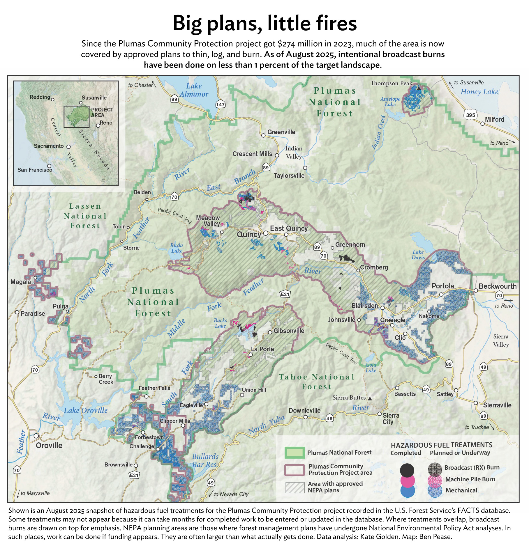
Some work has been done. In areas around Quincy and Meadow Valley, and near communities along Highway 70 toward Portola, mastication machines have been chewing brush and small trees into wood chips and spitting them back onto the landscape. Crews are also using chain saws and other machines to thin forests. These are steps preliminary to commercial logging, which has not started.
The Forest Service’s annual reports say 49,496 acres of Plumas Forest were treated in 2023 and 5,400 acres in 2024, about one-fifth of the goal. But it’s unclear how much safer the forest is. The reports do not say whether the treatment was thinning, logging, or intentional burning, nor where the activity occurred. Scientists and forest managers across the West have been debating for years how to measure forest resilience and community protection. Acreage is not reliable, says Bauer. A better measure would count an acre as treated when all the on-the-ground work is done, says Eric Edwards, whose research at UC Davis focuses on environmental and agricultural economics.
For all the wildfire crisis strategy’s hype of intentional burning and its protective benefits for both forests and communities, the Plumas plan is vague on acreage goals and enforcing the contractors’ burn objectives. It identifies all 285,000 acres for intentional fire, says Bauer. But unlike with thinning and logging, operators are not tied to burn goals. “It’s always a soft commitment,” Bauer says. Plumas Forest officials have reported 2,543 acres burned since October. Almost all of it was burning piles of branches and brush, not the essential low-intensity intentional fires that sweep across the forest floor. Those intentional broadcast burns total about 2,500 acres, Bay Nature and The Plumas Sun estimate, using Forest Service data with help from experts. That’s just under 1 percent of the target landscape.
In reports on the nationwide wildfire crisis strategy, the Forest Service has cited challenges to implementation, including inflated costs, a lack of timber market for small-diameter wood, employee housing costs, uncompetitive pay, and limited on-the-ground capacity.
Little of the information about progress on the Plumas Community Protection projects has come from Plumas Forest officials, who have given short shrift to reporters’ questions since late January. Calls to the Plumas Forest supervisor’s office have gone unreturned, sometimes careening in bizarre redirects that include a scratchy recording of the Smokey Bear song. Reporters’ written questions, submitted in February to the Forest Service’s public affairs office in Washington, D.C., have gone unanswered. The Trump administration has blocked press access to agency scientists and taken down the interactive map that once documented project progress. The only interview granted since late January was a half hour, in August, on how to use agency data. Links to websites available in January now post “page not found” or, more cynically, “Looks like you hit the end of the trail.”
Some Plumas residents say the Forest Service has shirked its obligation to keep the public informed. John Sheehan, who has paid close attention to Plumas National Forest issues since 1992, was dismayed by knowing “next to nothing” about the Community Protection plan, he says. “When the government’s going to do something this big and this close to communities, it needs to be in touch with the people affected. The Plumas Forest just isn’t.” Josh Hart, a spokesperson for Feather River Action!, one of the plaintiffs in the lawsuit filed by environmental groups, complains about the dearth of public information for “the most significant plans for the Plumas National Forest ever in history.”
The agency has provided no accounting of how it has spent the $274 million. Public records and interviews with contractors reveal that around $202 million has been allocated in contracts for thinning and logging. Another $5 million went to prescribed burning, Bauer says. The Great Basin Institute received approximately $2 million for wildlife surveys. Approximately $50 million went to environmental analyses. That leaves $15 million unaccounted for. Some went directly to salaries, says Bauer. Most of the rest likely went to planning, he says. “That funding source is gone.”
The agency acknowledged in a 2025 national report that it had run through most of its BIL and IRA money. “Fully realizing the vision laid out by the Wildfire Crisis Strategy will require further, sustained investments,” the report says.
Hamstrung
Two full years since the launch of the Plumas Community Protection plan, the Plumas Forest’s hamstrung capacity raises questions about its ability to execute its own plan. Recent Trump administration layoffs cap years of reduced staffing. The Plumas Forest supervisor position was vacant for over a year. A merry-go-round of vacancies and short-term appointments often leaves partners and contractors in limbo, waiting for decisions to allow their work to proceed, says Jim Wilcox, a Plumas Corporation senior adviser who has worked on Forest Service restoration contracts for 35 years. “The delays drive everyone crazy.”
Other agencies and private companies are filling some of the gaps, which is part of the national strategy to address the wildfire crisis. They have done most of the required environmental analyses and are slated for much of the on-the-ground project work. The Forest Service has always used non-agency partners to do logging and burning, Moghaddas says, but with giant 70,000-acre units, the partnerships are larger and more complex. “The Forest Service can’t do it alone,” he says. Avery calls it a cultural shift: “I have seen an evolution in the Forest Service’s willingness to work with partners, which I thought was a good thing in response to a tragedy.”

The shift away from federal oversight of national forest land, though, worries Hall. Forest Service crews have generally been composed of people who care about protecting and preserving public lands, he says. “I love the idea of public land and having so much of it available . . . If we don’t have someone obligated to steward it—and that’s the Forest Service folks—we’re all in trouble.”
While STEM is a company of experienced loggers and NFF has demonstrated dedication to national forest health, these are new ventures for each organization. Ivy Kostick, NFF’s forester for the 70,000-acre project, is breaking it down into manageable pieces, she says: “How do you eat an elephant? One bite at a time?”
Moment of opportunity
Now, four years after the Dixie Fire, the ambitious Plumas Community Protection plan is still more promise than on-the-ground reality. Because funding has already been obligated, the major work should eventually proceed, says Jake Blaufuss, a lifelong local and Quincy-based forester for American Forest Resource Council, a trade association that advocates for sustainable forests. Commercial logging will generate revenue that can be reinvested in prescribed burning and other remaining work, Blaufuss says. Jeff Holland, a spokesperson for STEM, says 2026 will bring enough activity “where people will actually see the difference.”
For Bauer, the plan’s $274 million bought something essential: environmental analyses. While the Forest Service provided no financial details, partners close to the project confirmed that some of the federal funds went to the biological surveys, stream assessments, archaeological reviews, and timber stand counts required under NEPA. Today, most of the Plumas Community Protection landscape is covered by an approved plan. While currently there’s not a lot of actual activity, when it begins, Blaufuss says, these documents will “allow the Forest Service to be nimble.”
Bauer measures the scale of success by the scale of prescribed fire. The goal for both forest resilience and community protection is to follow thinning and logging with burning; it is the goal for the Plumas Community Protection project. What haunts Bauer are the places around Greenville where pre-Dixie plans called for aggressive thinning followed by prescribed fire. Most never saw a chain saw or a drip torch, and most were totally incinerated when Dixie blazed through. “We just didn’t get to them,” Bauer says. If the Plumas Community Protection project does not complete the plan for prescribed burning, “it’s essentially a roulette scenario,” he says. And so far it hasn’t.
What the plan has done is to advance the understanding that fire is essential for forest resilience and community safety. Forest managers are thinking creatively about how to achieve that. The conversation about forest management is shifting.
Fire rejuvenates forest ecosystems. While the Dixie Fire’s toll on the Plumas and its communities has been horrific, it leaves them poised for renewal—like silver lupines waiting in the seed bank to burst into flower. If the Plumas Forest project can gain additional funding and muster sufficient political will, the grand plan to protect all that did not burn may advance. “We know we need wholesale change in the way we’re managing the forest,” says Blaufuss. “This is our chance.”
Tanvi Dutta Gupta and Anushuya Thapa contributed reporting. This article was supported by the March Conservation Fund.
This story was originally published by Grist with the headline The ambitious plan to protect Northern California’s Plumas National Forest from wildfires on Oct 7, 2025.