
Man, machine and mutton: Inside the plan to prevent the next SoCal fire disaster
Nine months after one of the worst fires the region has seen in recorded history, a helicopter carrying two of the most consequential politicians in the fight against Southern California’s wildfires soared over the Santa Monica Mountains. Rows of jagged peaks slowly revealed steep canyons. The land was blotchy: some parts were covered in thick, green and shrubby native chaparral plants; others were blackened, comprised mostly by fire-stricken earth where chaparral used to thrive; and still others were blanketed by bone-dry golden grasses where the land had years ago been choked out by fire.Amid this tapestry was a scattering of homes and businesses with only a handful of roads snaking out: Topanga. The dangers, should a fire roar down the canyon, were painfully clear at a thousand feet.“If there are any issues on the Boulevard…” County Supervisor Lindsey Horvath said into her headset, trailing off.“The community is trapped,” said Wade Crowfoot, California Secretary for Natural Resources, finishing the thought.Over the same mountains where the Palisades fire roared, the supervisor and secretary were observing the state’s nearly 675-acre flagship project to stop the Santa Monica Mountains’ next firestorm from devouring homes and killing residents. Crews from the Los Angeles County Fire Department and the Mountains Recreation and Conservation Authority, a local land management agency, were cutting a miles-long web of fuel breaks in the Northern Santa Monicas between Topanga and Calabasas. In the spring, they hope to perform a prescribed burn along the break. Just northwest, on the other side of Calabasas, Ventura County Fire Department deployed 500 goats and 100 sheep to eat acres of invasive grasses that are prone to conflagration. A fire crew walks in the Santa Monica Mountains during a wildfire risk reduction project on Oct. 8. (Myung J. Chun / Los Angeles Times) It’s just a fraction of the work state leaders and local fire crews hope to someday accomplish, yet the scale and speed of the effort has already made some ecology and fire experts uneasy. (The goats, however, have enjoyed virtually universal praise.) While many firefighters and fire officials support the creation of fuel breaks, which offer better access to remote areas during a fire fight, fire ecologists warn that if not done carefully, fuel breaks can make the landscape even more fire-prone by inadvertently replacing chaparral with flammable invasive grasses.Yet, after the Palisades fire last January, many state leaders and residents in the Santa Monicas feel it’s better to act now — even if the plan is a bit experimental — given the mountains will almost certainly burn again, and likely soon. Goats help clear vegetation in the Upper Las Virgenes Canyon Open Space Preserve as part of a wildfire risk reduction project. (Myung J. Chun / Los Angeles Times) In March, Gov. Gavin Newsom signed an executive order streamlining the approval process for these projects. Instead of seeking multiple permits through separate lengthy processes — via the California Environmental Quality Act, Coastal Act, Endangered Species Act, and Native Plant Protection Act (among others) — applicants can now submit projects directly to the California Natural Resources Agency and California Environmental Protection Agency, which ensures compliance with all of the relevant laws.Consequently, the state has approved well over 100 projects in mere months. Before, it was not uncommon for projects to sit in limbo for years awaiting various approvals.In April, the state legislature and Newsom approved the early release of funds from a $10 billion climate bond that California voters approved last November for these types of projects. The Santa Monica Mountains Conservancy, which received over $31 million of that funding, awarded just over $3 million to L.A. County and Ventura County fire departments and the MRCA to complete the project.On Oct. 8, Horvath and Crowfoot watched from a ridgeline northwest of Topanga as crews below maneuvered a remote-controlled machine — named the Green Climber after its color and ability to navigate steep slopes — to chew up shrubs on the hillsides. Others used a claw affixed to the arm of a bright-red excavator to rip out plants. Los Angeles County Supervisor Lindsey Horvath flies over the Malibu coastline during a tour of a wildfire risk reduction project in the Santa Monica Mountains. (Myung J. Chun/Los Angeles Times) The goal was to create a new fuel break on a plot of land that is one of the few areas in the Santa Monicas that hasn’t burned in the last seven years, said Drew Smith, assistant fire chief with the L.A. County Fire Department. “Going into the fall, our biggest vulnerabilities are all this right here.”Left alone, chaparral typically burns every 30 to 130 years, historically due to lightning strikes. But as Westerners began to settle the region, fires became more frequent. For example, Malibu Canyon — which last burned in the Franklin fire, just a month before the Palisades fire — now experiences fire roughly every eight years.As the fire frequency chokes out the native chaparral ecosystem, fast growing, extremely flammable invasive grasses take over, making it even more likely that a loose cigarette or downed power line will ignite a devastating blaze. Scientists call this death spiral the human-grass-fire cycle. Stopping it is no simple task. And reversing it, some experts fear, may be borderline impossible.The state’s current approach, laid out by a panel of independent scientists working with California’s wildfire task force, is three-pronged.First: home hardening, defensible space and evacuation planning to ensure that if a monster fire starts, it causes the smallest amount of death and destruction. Second: Techniques to prevent fire ignitions in the first place, such as deploying arson watch teams on high-wind days.Third: Creating a network of fuel breaks. Fuel breaks are the most hotly debated, in part because fuel breaks alone do little to stop a wind-driven fire throwing embers miles away.But fire officials who have relied on fuel breaks during disasters argue that such fuel breaks can still play “a significant tactical role,” said Smith, allowing crews to reach the fire — or a new spot fire ignited by an ember — before it blows through a community. A Los Angeles County Fire Department excavator with a claw grapple clears vegetation in the Santa Monica Mountains. (Myung J. Chun/Los Angeles Times) But Dan Cooper, principal conservation biologist with the Resource Conservation District of the Santa Monica Mountains, said there’s little scientific evidence yet that indicates fuel breaks are effective.And because creating fuel breaks harms ecosystems and, at worst, can make them even more fire prone, fire ecologists warn they need to be deployed strategically. As such, the speed at which the state is approving projects, they say, is concerning.Alexandra Syphard, senior research scientist at the Conservation Biology Institute and a leading Southern California fire ecologist, noted that the fuel break the Santa Monica Mountains team is creating near Topanga seems to cut right through healthy chaparral. If the fire crews do not routinely maintain the fuel break, it will be flammable golden grasses that grow back, not more ignition-resistant chaparral. A remote controlled masticator — called the “Green Climber” — mulches flammable vegetation in Topanga to keep flames at a low height. (Myung J. Chun / Los Angeles Times) And the choices land managers make today can have significant consequences down the line: While fire crews and local conservationists are experimenting with how to restore chaparral to grass-filled areas, in the studies Syphard has looked at, once chaparral is gone, it seldom comes back.For Cooper, the trade-offs of wildfire risk reduction get at a fundamental tension of living in the Santa Monicas. People move to places like Topanga, in part, because they love the chaparral-dotted vistas, the backyard oak woodlands and the privacy of life in the canyon. Yet, it’s that same environment that imperils them. “What are you going to do about it? Pave the Santa Monicas? A lot of the old fire guys want to make everything grass in the Santa Monicas because grass fires are just easier to put out,” he said. “We need to learn how to live with fire — in a lot more sober way.”
Local fire crews are launching a sweeping effort to prevent future wildfires in the Santa Monica Mountains. It entails using both animals and machines to create fire breaks — a controversial solution in Southern California.
Nine months after one of the worst fires the region has seen in recorded history, a helicopter carrying two of the most consequential politicians in the fight against Southern California’s wildfires soared over the Santa Monica Mountains. Rows of jagged peaks slowly revealed steep canyons. The land was blotchy: some parts were covered in thick, green and shrubby native chaparral plants; others were blackened, comprised mostly by fire-stricken earth where chaparral used to thrive; and still others were blanketed by bone-dry golden grasses where the land had years ago been choked out by fire.
Amid this tapestry was a scattering of homes and businesses with only a handful of roads snaking out: Topanga. The dangers, should a fire roar down the canyon, were painfully clear at a thousand feet.
“If there are any issues on the Boulevard…” County Supervisor Lindsey Horvath said into her headset, trailing off.
“The community is trapped,” said Wade Crowfoot, California Secretary for Natural Resources, finishing the thought.
Over the same mountains where the Palisades fire roared, the supervisor and secretary were observing the state’s nearly 675-acre flagship project to stop the Santa Monica Mountains’ next firestorm from devouring homes and killing residents.
Crews from the Los Angeles County Fire Department and the Mountains Recreation and Conservation Authority, a local land management agency, were cutting a miles-long web of fuel breaks in the Northern Santa Monicas between Topanga and Calabasas. In the spring, they hope to perform a prescribed burn along the break. Just northwest, on the other side of Calabasas, Ventura County Fire Department deployed 500 goats and 100 sheep to eat acres of invasive grasses that are prone to conflagration.
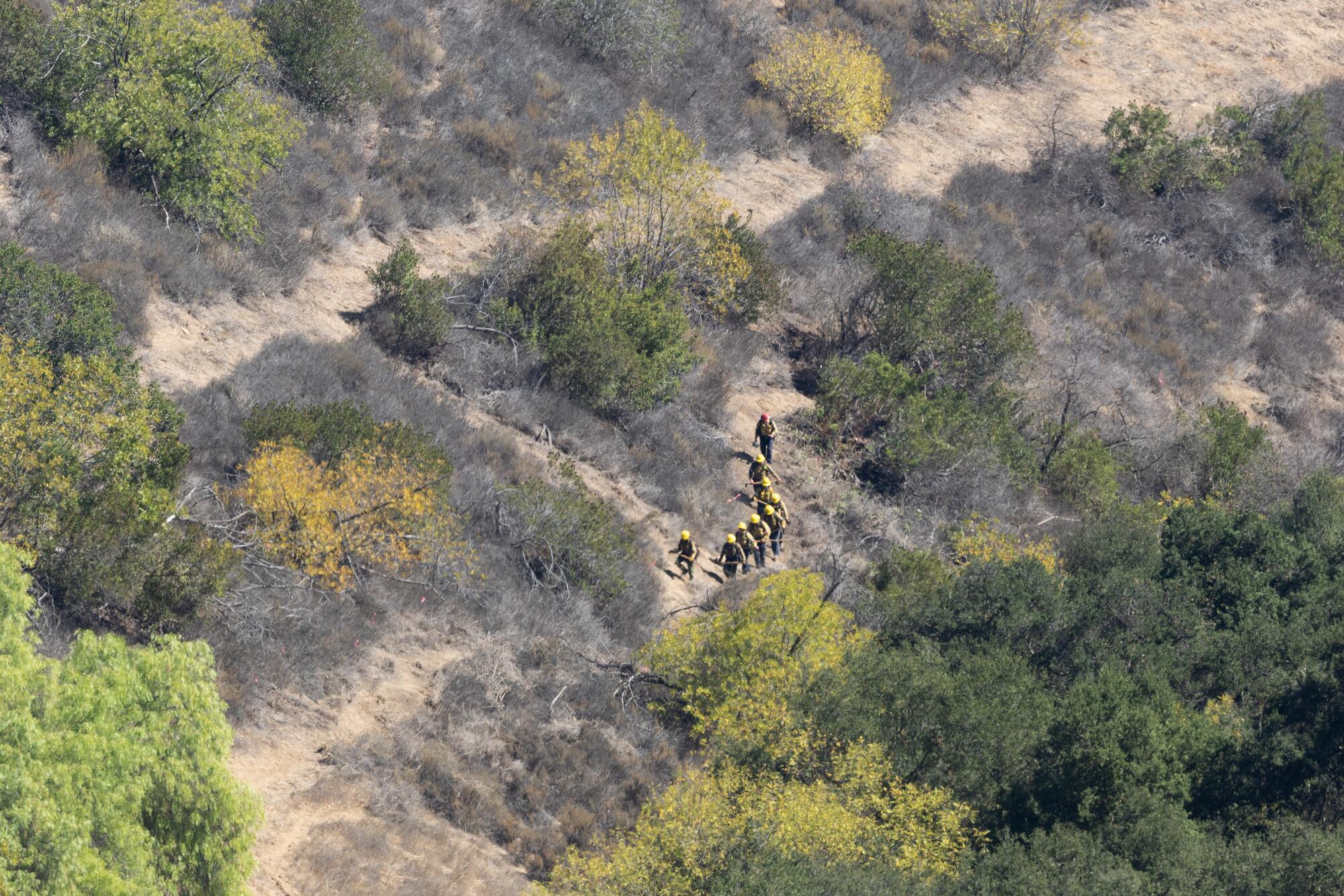
A fire crew walks in the Santa Monica Mountains during a wildfire risk reduction project on Oct. 8.
(Myung J. Chun / Los Angeles Times)
It’s just a fraction of the work state leaders and local fire crews hope to someday accomplish, yet the scale and speed of the effort has already made some ecology and fire experts uneasy.
(The goats, however, have enjoyed virtually universal praise.)
While many firefighters and fire officials support the creation of fuel breaks, which offer better access to remote areas during a fire fight, fire ecologists warn that if not done carefully, fuel breaks can make the landscape even more fire-prone by inadvertently replacing chaparral with flammable invasive grasses.
Yet, after the Palisades fire last January, many state leaders and residents in the Santa Monicas feel it’s better to act now — even if the plan is a bit experimental — given the mountains will almost certainly burn again, and likely soon.

Goats help clear vegetation in the Upper Las Virgenes Canyon Open Space Preserve as part of a wildfire risk reduction project.
(Myung J. Chun / Los Angeles Times)
In March, Gov. Gavin Newsom signed an executive order streamlining the approval process for these projects. Instead of seeking multiple permits through separate lengthy processes — via the California Environmental Quality Act, Coastal Act, Endangered Species Act, and Native Plant Protection Act (among others) — applicants can now submit projects directly to the California Natural Resources Agency and California Environmental Protection Agency, which ensures compliance with all of the relevant laws.
Consequently, the state has approved well over 100 projects in mere months. Before, it was not uncommon for projects to sit in limbo for years awaiting various approvals.
In April, the state legislature and Newsom approved the early release of funds from a $10 billion climate bond that California voters approved last November for these types of projects. The Santa Monica Mountains Conservancy, which received over $31 million of that funding, awarded just over $3 million to L.A. County and Ventura County fire departments and the MRCA to complete the project.
On Oct. 8, Horvath and Crowfoot watched from a ridgeline northwest of Topanga as crews below maneuvered a remote-controlled machine — named the Green Climber after its color and ability to navigate steep slopes — to chew up shrubs on the hillsides. Others used a claw affixed to the arm of a bright-red excavator to rip out plants.
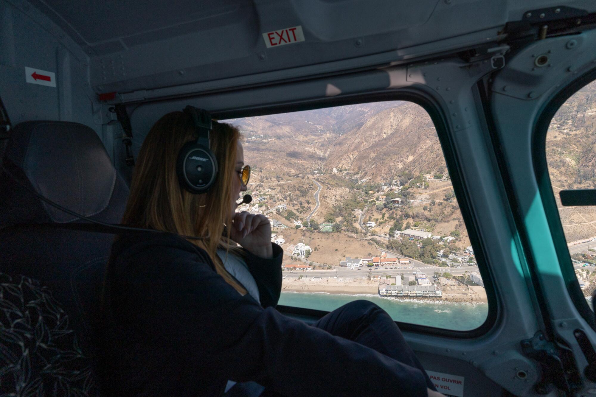
Los Angeles County Supervisor Lindsey Horvath flies over the Malibu coastline during a tour of a wildfire risk reduction project in the Santa Monica Mountains.
(Myung J. Chun/Los Angeles Times)
The goal was to create a new fuel break on a plot of land that is one of the few areas in the Santa Monicas that hasn’t burned in the last seven years, said Drew Smith, assistant fire chief with the L.A. County Fire Department. “Going into the fall, our biggest vulnerabilities are all this right here.”
Left alone, chaparral typically burns every 30 to 130 years, historically due to lightning strikes. But as Westerners began to settle the region, fires became more frequent. For example, Malibu Canyon — which last burned in the Franklin fire, just a month before the Palisades fire — now experiences fire roughly every eight years.
As the fire frequency chokes out the native chaparral ecosystem, fast growing, extremely flammable invasive grasses take over, making it even more likely that a loose cigarette or downed power line will ignite a devastating blaze. Scientists call this death spiral the human-grass-fire cycle. Stopping it is no simple task. And reversing it, some experts fear, may be borderline impossible.
The state’s current approach, laid out by a panel of independent scientists working with California’s wildfire task force, is three-pronged.
First: home hardening, defensible space and evacuation planning to ensure that if a monster fire starts, it causes the smallest amount of death and destruction.
Second: Techniques to prevent fire ignitions in the first place, such as deploying arson watch teams on high-wind days.
Third: Creating a network of fuel breaks.
Fuel breaks are the most hotly debated, in part because fuel breaks alone do little to stop a wind-driven fire throwing embers miles away.
But fire officials who have relied on fuel breaks during disasters argue that such fuel breaks can still play “a significant tactical role,” said Smith, allowing crews to reach the fire — or a new spot fire ignited by an ember — before it blows through a community.
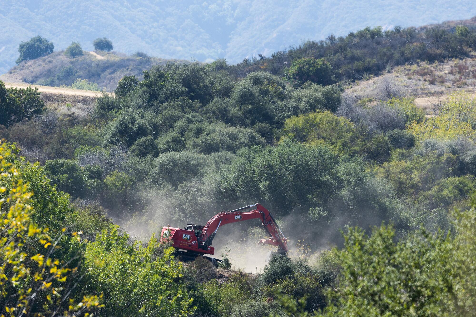
A Los Angeles County Fire Department excavator with a claw grapple clears vegetation in the Santa Monica Mountains.
(Myung J. Chun/Los Angeles Times)
But Dan Cooper, principal conservation biologist with the Resource Conservation District of the Santa Monica Mountains, said there’s little scientific evidence yet that indicates fuel breaks are effective.
And because creating fuel breaks harms ecosystems and, at worst, can make them even more fire prone, fire ecologists warn they need to be deployed strategically. As such, the speed at which the state is approving projects, they say, is concerning.
Alexandra Syphard, senior research scientist at the Conservation Biology Institute and a leading Southern California fire ecologist, noted that the fuel break the Santa Monica Mountains team is creating near Topanga seems to cut right through healthy chaparral. If the fire crews do not routinely maintain the fuel break, it will be flammable golden grasses that grow back, not more ignition-resistant chaparral.
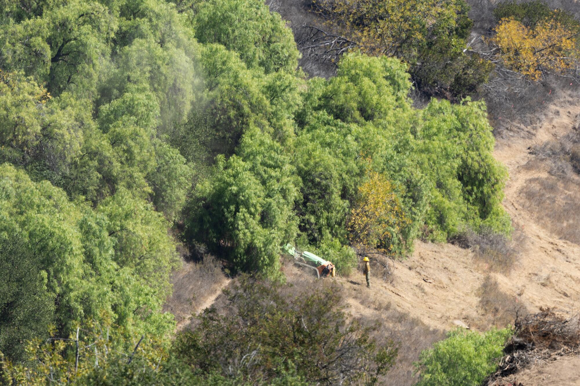
A remote controlled masticator — called the “Green Climber” — mulches flammable vegetation in Topanga to keep flames at a low height.
(Myung J. Chun / Los Angeles Times)
And the choices land managers make today can have significant consequences down the line: While fire crews and local conservationists are experimenting with how to restore chaparral to grass-filled areas, in the studies Syphard has looked at, once chaparral is gone, it seldom comes back.
For Cooper, the trade-offs of wildfire risk reduction get at a fundamental tension of living in the Santa Monicas. People move to places like Topanga, in part, because they love the chaparral-dotted vistas, the backyard oak woodlands and the privacy of life in the canyon. Yet, it’s that same environment that imperils them.
“What are you going to do about it? Pave the Santa Monicas? A lot of the old fire guys want to make everything grass in the Santa Monicas because grass fires are just easier to put out,” he said. “We need to learn how to live with fire — in a lot more sober way.”