
Pentagon plan pits U.S. Marines against California off-roaders and civilian pilots
LUCERNE VALLEY, Calif. — The U.S. Marine Corps tried once to occupy this remote stretch of California desert beloved by off-roaders — but officials managed eventually to broker a deal that allowed both leathernecks and dirt riders to share the same rocky canyons and wrinkled mountains of Johnson Valley.Now, more than a decade later, the Marines are back — and this time, they want the skies.The Pentagon has proposed restricting civilian air traffic above much of the Johnson Valley Off-Highway Vehicle Area to expand and support training exercises. But those who frequent the area just west of the Twentynine Palms Marine base say the proposal would severely limit recreational access and reduce safety.They say the airspace restrictions could prevent rescue helicopters from evacuating injured motorists, and threaten the famed King of the Hammers off-road race that’s held there each year.And perhaps most crucially, they fear the proposal — which must be approved by the Federal Aviation Administration — is just the first step toward the Marines ending public access to an area that was set aside by Congress for public use.“It feels like it’s literally just another way for them to take the land, but from above,” said Shannon Welch, vice president of the off-road group Blue Ribbon Coalition.The proposal has also drawn criticism from aviation officials, who say the restrictions could affect the operations of small local airports and add time and cost to commercial flights.The military says such fears are overblown.Recently, base officials said that the proposal would restrict the airspace for only up to 60 days per year. Project documents say the Marines are hoping the FAA will consider adding more days after the first year, but the base officials told The Times they would not seek additional days of activation over the portion of Johnson Valley that’s shared with the public. They are also working on mitigation measures that would enable them to share the skies even when the restrictions are active, they said.“There is no intention to restrict public access to Johnson Valley,” said Cindy Smith, land management specialist with the base’s government and external affairs. King of the Hammers founder Dave Cole walks along sand dunes in the Johnson Valley OHV Area where the military wants to impose restrictions on civilian aircraft. (Gina Ferazzi/Los Angeles Times) Johnson Valley devotee Dave Cole lives on 15 acres that back up onto the OHV area. From his front door, he can hop in a side-by-side and traverse miles of rolling sand dunes and rugged boulder piles. The vastness reminds him of the ocean, where constantly shifting tides mean that no two trips yield the same experience. And in the world of motorized recreation, the 96,000-acre riding area simply has no peer.“Going off-roading and those kinds of things, that’s surfing for me, and this is like Oahu. It’s beachfront,” Cole said.One recent afternoon, he stood on a ridge above a sprawling dry lakebed. There, in a few months, a temporary city called Hammertown would arise from the sun-baked sand. Some 80,000 people were expected to watch rock-crawling competitions and races, camp out and hear vendors pitch the latest in automotive technology. The King of the Hammers off-road vehicle competition is held each year in February. (Dennis Utt) Cole co-founded King of the Hammers in 2007 — in part to fend off a westward expansion by the Marine Corps. He thought an off-roading competition would draw attention to the Bureau of Land Management-maintained area and demonstrate the importance of keeping it open to the public.The two-week festival has since grown into one of the largest events on public land outside of Burning Man and a report commissioned by San Bernardino County estimated the race’s economic impact to be $34 million in 2023.As for the Marines’ expansion ambitions, they were addressed by a compromise in the 2014 defense bill. The legislation set aside about 43,000 acres of Johnson Valley for recreational use, 79,000 acres for the Marines and 53,000 to be shared. The Marines are permitted to close that shared-use area for two 30-day periods each year.The proposed airspace restrictions would stretch above much of the recreational area, including the entire shared-use area.King of the Hammers relies on helicopters and drones to respond to emergencies and to livestream the event worldwide. Welch, of the Blue Ribbon Coalition, described a potential loss of air support as “catastrophic.” King of the Hammers is an off-road race that combines desert racing and rock crawling. This race is held in February on Means Dry Lake at Johnson Valley. (Dennis Utt) Cole isn’t as worried about King of the Hammers. He believes a compromise to accommodate the event is possible and even likely. He’s more concerned that the proposal may mark the start of a broader takeover of the same area the Marines sought to annex years ago. “It’s a different bite; same apple,” he said.Military airspace restrictions above other public lands often result in ground closures with little notice, Welch said. Such areas include BLM-managed lands in the vicinity of the White Sands Missile Range in southern New Mexico, as well as the Yuma Proving Grounds in Arizona, she said.“These two areas are cautionary tales for what happens when the military gains control of the skies — even if the land underneath remains technically public,” she wrote in an email.Marine Corps officials said they are committed to honoring the shared-use agreement, but that they need additional restricted airspace for training involving both piloted aircraft and drones.Col. Benjamin Adams, assistant chief of staff for the base’s training directorate, pointed to a directive from Defense Secretary Pete Hegseth that every squad must be armed with small drones by the end of fiscal year 2026. The Twentynine Palms base, with its 1,200 square miles of rugged training area, is one of the only places the Marines can perform large-scale combined-arms exercises, Adams said.“This is the golden jewel of the Marine Corps,” he said. “The training we complete here cannot be conducted anywhere else in the Marine Corps, period.”The Marines published a description of the airspace proposal in 2019, but multiple recreation advocates and local officials said they didn’t hear about it until the Marines released a draft environmental assessment last month.San Bernardino County Supervisor Dawn Rowe questions whether federal officials have a full understanding of how the restrictions would affect local residents. At least 36 medical helicopters responded to the Johnson Valley area last year, according to statistics provided to Rowe by the San Bernardino County Fire Protection District.“Nobody really looks up to say, ‘what are we sacrificing on the other end of it?’ Is it public safety? Access to public lands and recreation? Private property rights of inholders?” she said. “That falls to us on the outside who want to coexist with the Marines, who we respect, but also want to preserve the areas we have known and enjoyed for years.”Both the Yucca Valley Airport District and the San Bernardino County Airport Commission have voted to submit letters opposing the proposal. Both the Yucca Valley Airport District and the San Bernardino County Airport Commission have voted to submit letters opposing the Marine air restriction proposal. (Gina Ferazzi/Los Angeles Times) An increase in military flights through the Yucca Valley Airport’s traffic pattern would raise public safety and noise concerns, wrote board director Tim Lewis. He noted the military already has 31 special use airspaces within a 100 nautical-mile range of the Twentynine Palms base, with restrictions running almost continually from Barstow to Prescott, Ariz.The addition of even more restrictions is likely to impact commercial air travel, potentially reducing the number of flights through a heavily-used corridor, he wrote. And it would restrict the use of multiple small airports, including the Yucca Valley Airport, Twentynine Palms Airport, Big Bear City Airport, Needles Airport, Barstow-Daggett Airport and Apple Valley Airport, he wrote.“I think ultimately the Marines will find that the public opposition they’ve encountered will require them to make some compromises,” said Rep. Jay Obernolte (R-Big Bear Lake), who is also a pilot.When it comes to Big Bear, the proposed restrictions overlap with a line of approach for pilots using instrument flight rules, said Obernolte, who previously served on the Big Bear City Airport board. If the proposal is approved, those pilots would not be able to land at the airport under current procedures, he said.Obernolte is seeking to have a provision added to this year’s defense bill that would condition any expansion on the Marines complying with a previous law that requires them to work with the FAA to better alert pilots to the status of restricted airspace. “This is a real sore issue,” pilot Jim Bagley said recently as he flew a small airplane through skies the U.S. Marine Corps is seeking to restrict. (Gina Ferazzi/Los Angeles Times) “This is a real sore issue,” said Jim Bagley from the cockpit of his 1955 Cessna 172 as it roared through the airspace that would be subject to restriction. Thousands of feet below, a smattering of old homesteads spread out like playing cards on a poker table.The former three-time mayor of Twentynine Palms, Bagley is now a recreational pilot and flight instructor who sits on the county Airport Commission. For him, backcountry flying is just another mode of sightseeing, like hiking through Yosemite or boating beneath Niagara Falls.Open areas like Johnson Valley — where you can race your side-by-side as fast as you want or land an ultralight on a dry lake bed — are unique American experiences that are growing rarer, he said.Yet even Bagley, a close watcher of the project who had given the draft environmental assessment a careful read, did not initially realize some of the restrictions would be limited to 60 days. That is explained in an appendix more than halfway through the 394-page document. The rest repeatedly frames the proposal as the establishment of permanent restricted areas. Smith said that notice of the project was published in local newspapers and sent to various stakeholders. Public feedback will be incorporated in both the final environmental assessment and a letter of procedure specifying how the proposal will be carried out, she said. The Marines are already working with the FAA on that letter, which will enable the public to use the airspace above the shared-use area for low-level flights, including rescue helicopters, even when the restrictions are active, provided the ground is open, she said. The letter will also accommodate all aircraft approaching Big Bear, said Andy Chatelin, director of the base’s range management and development division. Chatelin pointed out that the proposal has already gone through an FAA aeronautical study and safety risk management panel to determine its impacts on the National Airspace System. A final decision is expected in the fall of 2026, he said.Had the Marine Corps held public meetings on the proposal and publicized the 60-day cap, some of the backlash against it could likely have been avoided, Bagley said. He has no issue with the military using portions of the airspace for training when they need it, he said.“What I object to is taking away public access to the public lands — and those public lands include the airspace above them.”
A proposal by the U.S. Marines to restrict civilian flight traffic above Johnson Valley OHV Area has drawn outrage from off-roaders and civilian pilots.
LUCERNE VALLEY, Calif. — The U.S. Marine Corps tried once to occupy this remote stretch of California desert beloved by off-roaders — but officials managed eventually to broker a deal that allowed both leathernecks and dirt riders to share the same rocky canyons and wrinkled mountains of Johnson Valley.
Now, more than a decade later, the Marines are back — and this time, they want the skies.
The Pentagon has proposed restricting civilian air traffic above much of the Johnson Valley Off-Highway Vehicle Area to expand and support training exercises. But those who frequent the area just west of the Twentynine Palms Marine base say the proposal would severely limit recreational access and reduce safety.
They say the airspace restrictions could prevent rescue helicopters from evacuating injured motorists, and threaten the famed King of the Hammers off-road race that’s held there each year.
And perhaps most crucially, they fear the proposal — which must be approved by the Federal Aviation Administration — is just the first step toward the Marines ending public access to an area that was set aside by Congress for public use.
“It feels like it’s literally just another way for them to take the land, but from above,” said Shannon Welch, vice president of the off-road group Blue Ribbon Coalition.
The proposal has also drawn criticism from aviation officials, who say the restrictions could affect the operations of small local airports and add time and cost to commercial flights.
The military says such fears are overblown.
Recently, base officials said that the proposal would restrict the airspace for only up to 60 days per year. Project documents say the Marines are hoping the FAA will consider adding more days after the first year, but the base officials told The Times they would not seek additional days of activation over the portion of Johnson Valley that’s shared with the public. They are also working on mitigation measures that would enable them to share the skies even when the restrictions are active, they said.
“There is no intention to restrict public access to Johnson Valley,” said Cindy Smith, land management specialist with the base’s government and external affairs.
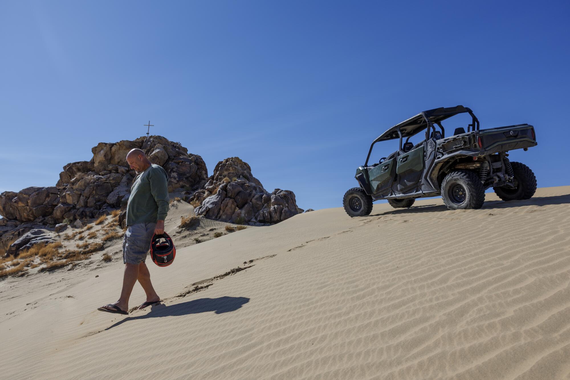
King of the Hammers founder Dave Cole walks along sand dunes in the Johnson Valley OHV Area where the military wants to impose restrictions on civilian aircraft.
(Gina Ferazzi/Los Angeles Times)
Johnson Valley devotee Dave Cole lives on 15 acres that back up onto the OHV area. From his front door, he can hop in a side-by-side and traverse miles of rolling sand dunes and rugged boulder piles. The vastness reminds him of the ocean, where constantly shifting tides mean that no two trips yield the same experience. And in the world of motorized recreation, the 96,000-acre riding area simply has no peer.
“Going off-roading and those kinds of things, that’s surfing for me, and this is like Oahu. It’s beachfront,” Cole said.
One recent afternoon, he stood on a ridge above a sprawling dry lakebed. There, in a few months, a temporary city called Hammertown would arise from the sun-baked sand. Some 80,000 people were expected to watch rock-crawling competitions and races, camp out and hear vendors pitch the latest in automotive technology.
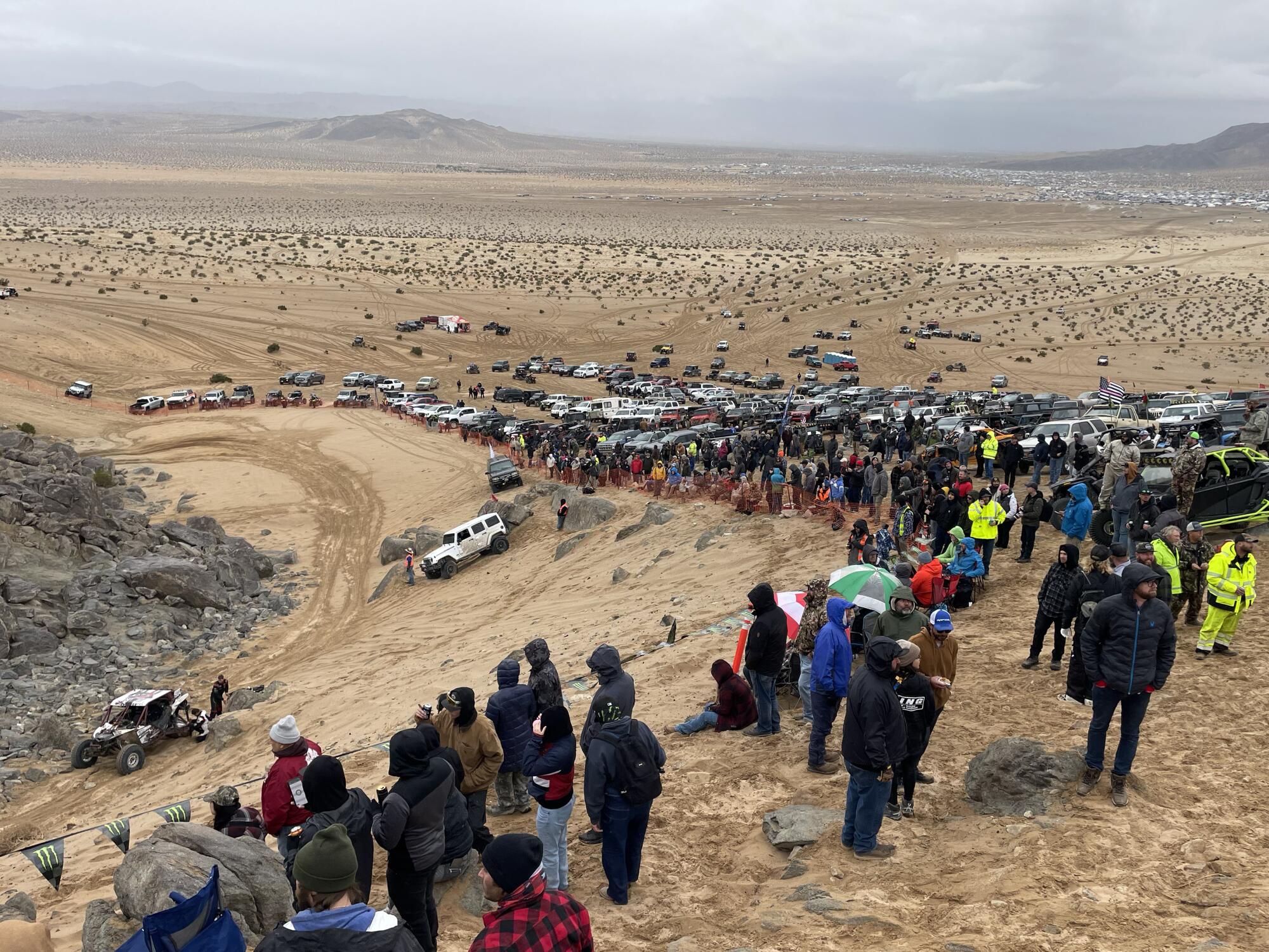
The King of the Hammers off-road vehicle competition is held each year in February.
(Dennis Utt)
Cole co-founded King of the Hammers in 2007 — in part to fend off a westward expansion by the Marine Corps. He thought an off-roading competition would draw attention to the Bureau of Land Management-maintained area and demonstrate the importance of keeping it open to the public.
The two-week festival has since grown into one of the largest events on public land outside of Burning Man and a report commissioned by San Bernardino County estimated the race’s economic impact to be $34 million in 2023.
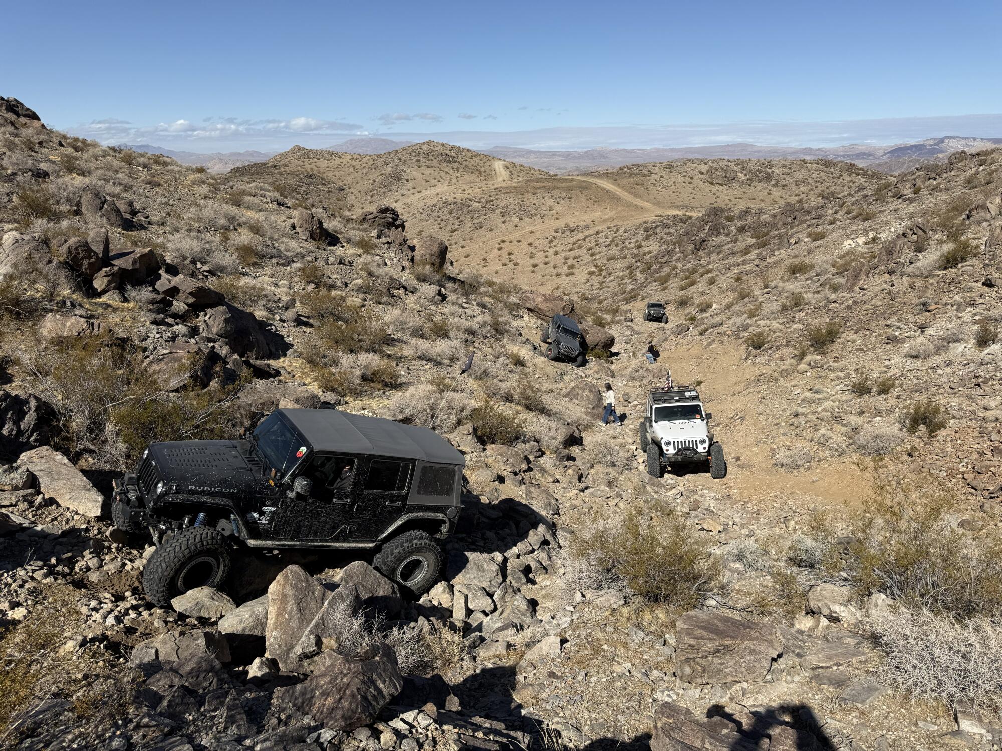
As for the Marines’ expansion ambitions, they were addressed by a compromise in the 2014 defense bill. The legislation set aside about 43,000 acres of Johnson Valley for recreational use, 79,000 acres for the Marines and 53,000 to be shared. The Marines are permitted to close that shared-use area for two 30-day periods each year.
The proposed airspace restrictions would stretch above much of the recreational area, including the entire shared-use area.
King of the Hammers relies on helicopters and drones to respond to emergencies and to livestream the event worldwide. Welch, of the Blue Ribbon Coalition, described a potential loss of air support as “catastrophic.”
King of the Hammers is an off-road race that combines desert racing and rock crawling. This race is held in February on Means Dry Lake at Johnson Valley.
(Dennis Utt)
Cole isn’t as worried about King of the Hammers. He believes a compromise to accommodate the event is possible and even likely. He’s more concerned that the proposal may mark the start of a broader takeover of the same area the Marines sought to annex years ago. “It’s a different bite; same apple,” he said.
Military airspace restrictions above other public lands often result in ground closures with little notice, Welch said. Such areas include BLM-managed lands in the vicinity of the White Sands Missile Range in southern New Mexico, as well as the Yuma Proving Grounds in Arizona, she said.
“These two areas are cautionary tales for what happens when the military gains control of the skies — even if the land underneath remains technically public,” she wrote in an email.
Marine Corps officials said they are committed to honoring the shared-use agreement, but that they need additional restricted airspace for training involving both piloted aircraft and drones.
Col. Benjamin Adams, assistant chief of staff for the base’s training directorate, pointed to a directive from Defense Secretary Pete Hegseth that every squad must be armed with small drones by the end of fiscal year 2026. The Twentynine Palms base, with its 1,200 square miles of rugged training area, is one of the only places the Marines can perform large-scale combined-arms exercises, Adams said.
“This is the golden jewel of the Marine Corps,” he said. “The training we complete here cannot be conducted anywhere else in the Marine Corps, period.”
The Marines published a description of the airspace proposal in 2019, but multiple recreation advocates and local officials said they didn’t hear about it until the Marines released a draft environmental assessment last month.
San Bernardino County Supervisor Dawn Rowe questions whether federal officials have a full understanding of how the restrictions would affect local residents. At least 36 medical helicopters responded to the Johnson Valley area last year, according to statistics provided to Rowe by the San Bernardino County Fire Protection District.
“Nobody really looks up to say, ‘what are we sacrificing on the other end of it?’ Is it public safety? Access to public lands and recreation? Private property rights of inholders?” she said. “That falls to us on the outside who want to coexist with the Marines, who we respect, but also want to preserve the areas we have known and enjoyed for years.”
Both the Yucca Valley Airport District and the San Bernardino County Airport Commission have voted to submit letters opposing the proposal.
Both the Yucca Valley Airport District and the San Bernardino County Airport Commission have voted to submit letters opposing the Marine air restriction proposal.
(Gina Ferazzi/Los Angeles Times)
An increase in military flights through the Yucca Valley Airport’s traffic pattern would raise public safety and noise concerns, wrote board director Tim Lewis. He noted the military already has 31 special use airspaces within a 100 nautical-mile range of the Twentynine Palms base, with restrictions running almost continually from Barstow to Prescott, Ariz.
The addition of even more restrictions is likely to impact commercial air travel, potentially reducing the number of flights through a heavily-used corridor, he wrote. And it would restrict the use of multiple small airports, including the Yucca Valley Airport, Twentynine Palms Airport, Big Bear City Airport, Needles Airport, Barstow-Daggett Airport and Apple Valley Airport, he wrote.
“I think ultimately the Marines will find that the public opposition they’ve encountered will require them to make some compromises,” said Rep. Jay Obernolte (R-Big Bear Lake), who is also a pilot.
When it comes to Big Bear, the proposed restrictions overlap with a line of approach for pilots using instrument flight rules, said Obernolte, who previously served on the Big Bear City Airport board. If the proposal is approved, those pilots would not be able to land at the airport under current procedures, he said.
Obernolte is seeking to have a provision added to this year’s defense bill that would condition any expansion on the Marines complying with a previous law that requires them to work with the FAA to better alert pilots to the status of restricted airspace.
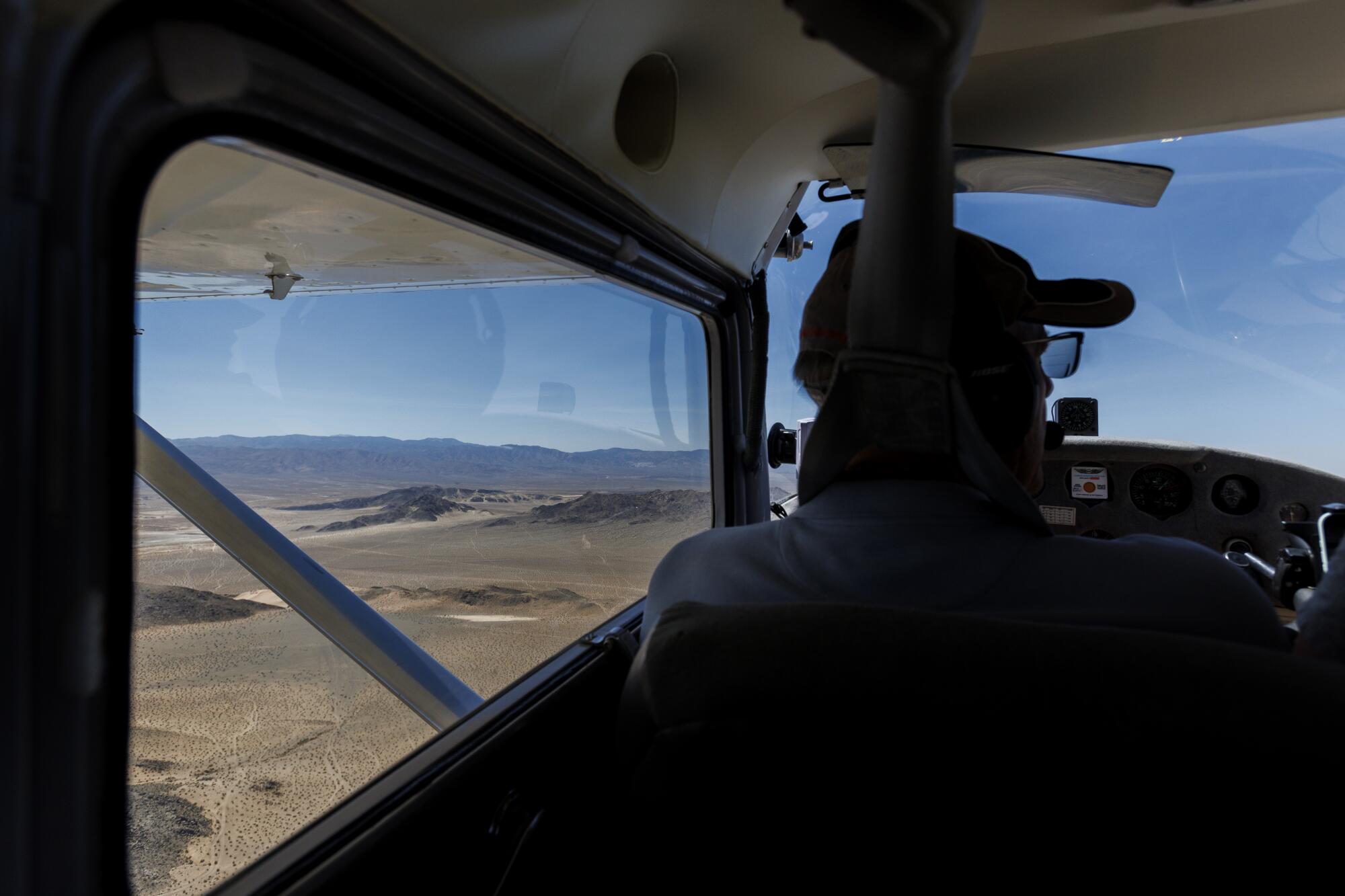
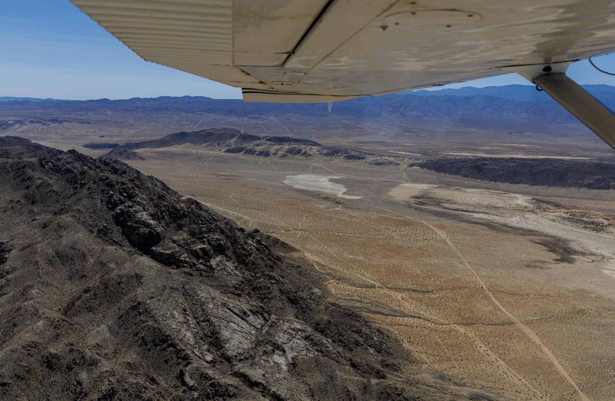
“This is a real sore issue,” pilot Jim Bagley said recently as he flew a small airplane through skies the U.S. Marine Corps is seeking to restrict.
(Gina Ferazzi/Los Angeles Times)
“This is a real sore issue,” said Jim Bagley from the cockpit of his 1955 Cessna 172 as it roared through the airspace that would be subject to restriction. Thousands of feet below, a smattering of old homesteads spread out like playing cards on a poker table.
The former three-time mayor of Twentynine Palms, Bagley is now a recreational pilot and flight instructor who sits on the county Airport Commission. For him, backcountry flying is just another mode of sightseeing, like hiking through Yosemite or boating beneath Niagara Falls.
Open areas like Johnson Valley — where you can race your side-by-side as fast as you want or land an ultralight on a dry lake bed — are unique American experiences that are growing rarer, he said.
Yet even Bagley, a close watcher of the project who had given the draft environmental assessment a careful read, did not initially realize some of the restrictions would be limited to 60 days. That is explained in an appendix more than halfway through the 394-page document. The rest repeatedly frames the proposal as the establishment of permanent restricted areas.
Smith said that notice of the project was published in local newspapers and sent to various stakeholders. Public feedback will be incorporated in both the final environmental assessment and a letter of procedure specifying how the proposal will be carried out, she said.
The Marines are already working with the FAA on that letter, which will enable the public to use the airspace above the shared-use area for low-level flights, including rescue helicopters, even when the restrictions are active, provided the ground is open, she said. The letter will also accommodate all aircraft approaching Big Bear, said Andy Chatelin, director of the base’s range management and development division.
Chatelin pointed out that the proposal has already gone through an FAA aeronautical study and safety risk management panel to determine its impacts on the National Airspace System. A final decision is expected in the fall of 2026, he said.
Had the Marine Corps held public meetings on the proposal and publicized the 60-day cap, some of the backlash against it could likely have been avoided, Bagley said. He has no issue with the military using portions of the airspace for training when they need it, he said.
“What I object to is taking away public access to the public lands — and those public lands include the airspace above them.”