
How Climate Change Is Increasing Landslide Risk Worldwide
The landslide behind my neighbor’s backyard doesn’t exist—not according to the New York State landslide map or Greene County’s hazard-mitigation plan or the federal inventory managed by the U.S. Geological Survey. But when you’re standing in the middle of the debris field, the violence of the event is still evident 14 years after it occurred. The fan of the landslide, where a surge of boulders and mud blasted the forest open after rushing down the steeper slopes of Arizona Mountain in the Catskills, is about 100 feet wide—an undulating plane of rocks, mangled tree trunks, and invasive plants such as Japanese stiltgrass that thrive in disturbed areas.On a hot July day the seasonal stream that runs through this ravine, named the Shingle Kill, is small enough to step over. When Tropical Storm Irene hovered over these mountains on August 28, 2011, the Shingle Kill swelled like all the otherwise unremarkable streams in the area, frothing downhill in a torrent the color of chocolate milk. This storm was a particularly bad one, dropping up to 18 inches of rain on the northeastern escarpment of the Catskills. Throughout the region explosive rivers eroded their banks, flooding towns and ripping away buildings.The first house the Shingle Kill passes as it emerges into our community belonged at the time to Diane and Ken Herchenroder, who had lived there for nearly three decades. In the past, when the Shingle Kill occasionally raged, they could hear rocks colliding in the streambed. But this time it was louder—and faster.On supporting science journalismIf you're enjoying this article, consider supporting our award-winning journalism by subscribing. By purchasing a subscription you are helping to ensure the future of impactful stories about the discoveries and ideas shaping our world today.From the screened-in front porch of their 1880s colonial, they saw the stream crest its banks. First it took out a 32-foot-long footbridge that connected one side of the property to the other. Then trees started coming downriver, crashing into a culvert at the bottom of the yard. The culvert clogged, washing out the road. Water got diverted across their lawn on one side of the stream, and in the other direction it blew out the garage side door, then the front doors. (Their lawn tractor was found downstream days later.) Diane watched her row of beloved lilac bushes, probably more than 100 years old and 15 feet tall, get ripped from their roots. “They just floated away. And we thought, that’s going to be it,” she recalls. “Then we heard a rumble like a train barreling down the mountain.”Less than 2,000 feet above, in a hollow high on Arizona Mountain, oversaturated soils released themselves into the headwaters of the Shingle Kill, picking up speed and whatever materials the flow encountered as it carved downhill.As the slope flattened out, the landslide blew open the channel and spread out, depositing a wall of uprooted trees just upstream of the house. A slurry of rocks and mud continued flowing, plugging the Shingle Kill streambed all the way to the road, where it was stopped by the debris dam at the culvert.Robert Titus, a retired geology professor, and his wife, Johanna Titus, explored the slide about a month later for their Kaatskill Geologist column in a local newspaper. “We don’t use the words ‘awe,’ ‘awesome’ or ‘awed’ very often; we save them for when they are truly appropriate,” they wrote. “This was one of those times.” They described scenes that were evidence of boulders “floating on the moving muds,” as well as hundreds of “twisted and broken trees” that had been thrown high above the stream bank and were now stranded on top of the ravine. The Tituses recently told me it was unlike anything they had seen before or since.In July 2025, days of heavy rain triggered multiple mudslides and rockslides in New York State's Adirondacks, including this one on Mount Colden. It blocked access to hiking trails in a popular recreation spot in the High Peaks Wilderness area.To this day, the scar where the landslide began is unmissable from miles away.That this landslide didn’t get recorded is somewhat a quirk of disaster recovery. Debris from the slide itself wasn’t the singular cause of damage to any buildings or roads, so there was no financial fingerprint. The slide didn’t injure or kill anyone. Landslides aren’t mapped in the same way that the Federal Emergency Management Agency, for instance, tracks flood zones and inundation risk, and a rate of occurrence can’t be modeled like a flood. Because landslide insurance practically doesn’t exist in most of the country, no one needs the data to assess actuarial risk for homeowners. According to the New York Geological Survey, the vast majority of landslides in the state go unreported.But the Shingle Kill landslide did change the mountainside that day. Joel DuBois, director of the Greene County Department of Soil and Water, visited the site in the days after Irene and reviewed some recent photos of the stream corridor that was affected by the debris flow. “There appear to be a number of cycles of incision and aggradation,” DuBois wrote. “That is to say that channel incision, or down-cutting, results in steeper bank angles and higher bank heights, leaving the adjacent hillsides susceptible to landslide” both during and after flood events. The sediment then flows downstream and accumulates at existing debris dams, which tends to cause channels to migrate laterally, he explained. That too can trigger landslide activity.The area remains vulnerable at a time when landslide risk is expected to increase across much of the northeastern U.S.—as well as a lot of the world. That’s because climate change is causing concentrated bursts of rain that fall over a short period to occur more frequently. Such intense rainfall events are known to be the biggest trigger of landslides.It’s not quite right to say landslides aren’t common in the Catskills, because this superold plateau has been eroding for perhaps a few hundred million years. On a nongeological timescale, though, landslide susceptibility isn’t something many people think about in New York State, and the state geological survey can estimate only that between 100 and 400 occur every year.As warmer temperatures lead to more moisture in the air, climate change is quickly warping that math. In the Northeast, the heaviest rainstorms are now 60 percent heavier than they were in the 1950s, according to the Fifth National Climate Assessment. In a 2023 study, researchers at Dartmouth College found that extreme precipitation in the region will increase by 52 percent by the end of this century, mostly because of a higher number of such events each year. “Our landscape has pretty much been in equilibrium, for the most part, since the glaciers left,” Andrew Kozlowski, a New York State geologist, explained during a 2022 USGS presentation. “With climate change, we may be shifting that equilibrium and throwing all of this completely off balance, and there’s going to be a natural readjustment.”“Landslide” is the broad term for the movement of soils, rocks, and other debris down a slope. There are several different classifications for landslides. Some, like the Shingle Kill debris flow, move far too fast to be outrun. More than any other factor, they are set off by an intense storm. Others, such as rotational slides—backward-curving masses of material that can be hundreds of feet deep—are more sensitive to rainfall over the course of a season. They can move very slowly when a destabilized slope takes months to fail.Landslides can happen pretty much anywhere certain conditions exist but are most common in very steep mountain terrain where plenty of rain falls. In 2024 the U.S. Landslide Susceptibility Index was released and stated that 44 percent of the land in the U.S. could potentially experience landslide activity. Susceptibility is based partly on where landslides have occurred previously, and it wasn’t until the past decade that high-resolution lidar made it possible for states to survey vast swaths of land for evidence and clues. The extent to which states have done so is uneven.Benjamin DeJong, director of the Vermont Geological Survey, says you can think of landslide susceptibility as an inexact recipe. You’re going to need steeper slopes to achieve some kind of baseload that puts weight on the slope. Next, add loose, unconsolidated materials that can become saturated with water. If those saturated materials are overlying or underlying another kind of material that has very different permeability, meaning its ability to take in water, that contrast is a big factor.“By far the year that had the greatest total landslides that I’ve recorded was 2024. Last year was completely off the scale.” —David Petley University of HullThen you look at what’s on the base and on the top of the slope. If the base, or toe, is undercut—by a road, for instance, or a meandering stream—that’s going to make the slope more susceptible. Overloading the top, or head, of a slope with weight also drives it toward failure.The fourth ingredient is the loss of vegetation that helps to hold soils together. In California, for example, this loss happens on a regular cycle with wildfires. Vermont, DeJong says, went through an experiment in the 1800s where “the state tried to turn itself into Scotland by cutting down all the trees and bringing in sheep.” It was a bad idea that caused erosion and mass slope failure everywhere. The state gave up on that plan and allowed the forests to regrow. The last variable is how the slope handles stormwater. With more extreme precipitation events, it doesn’t take much mismanagement of a slope for the heavy weight of rain to concentrate in ways that cause the slope to fail.Geologist David Petley, who writes the Landslide Blog for the American Geophysical Union, has been maintaining a database of deadly landslides worldwide since 2004. He’s seen a clear long-term trend. “But by far—by far—the year that had the greatest total landslides that I’ve recorded was 2024,” he says. “Last year was completely off the scale.” Why? “The most simple hypothesis is that it was the year with the highest-ever global temperature. I do genuinely think it’s that simple.” There’s solid evidence that high atmospheric temperature, and possibly high sea-surface temperatures as well, drove high-precipitation events globally. “Last year I saw an extraordinary frequency of big storms that were triggering hundreds of thousands of landslides,” Petley says. They occurred at different locations all over the world.In the U.S., the remnants of Hurricane Helene, which came ashore in Florida in September 2024, dumped between 20 and 30 inches of water over the mountains of North Carolina. The storm ended up triggering more than 2,000 landslides across the Southeast. According to the USGS, in some cases several smaller mudslides converged into a single channel, burying entire communities in debris. The total number of people killed by landslides specifically, versus by flooding or a combination of the two, is hard to parse. But one storm-triggered mudslide in Craigtown, N.C., swept through a house, killing 11 members of the Craig family for whom the town is named. During the storm, four successive landslides in that valley wiped out the town.In the Appalachian Mountains of North Carolina, very old landslides might have been “brought back into activity” during Helene, Petley explains, reactivated by staggeringly intense rain. Scientists at World Weather Attribution pinned that extra intensity on climate change, reporting that it had made the storm’s rainfall throughout the Southeast about 10 percent heavier and the “unprecedented” rainfall totals over three days about 70 percent more likely than they would have been otherwise.In California, where dramatic debris flows have long been a concern, climate change is making matters worse in two ways. Bigger, more destructive wildfires wipe out more of the vegetation that was stabilizing the landscape. And then atmospheric rivers—a newer phenomenon consisting of long, narrow conveyer belts of moisture—arrive, bringing a series of intense rainfall events. Between December 2022 and January 2023 nine back-to-back atmospheric rivers struck California, leading to more than 600 landslides.Climate change is increasing landslide risk globally in other ways. In high mountain regions such as the European Alps and the Himalayas, melting permafrost and retreating glaciers are destabilizing steep slopes. A catastrophic glacier collapse in Switzerland this past summer destroyed an entire village; thankfully officials evacuated people just before it happened, but one person was killed.A section of the Shingle Kill streambed 14 years after a debris flow occurred on Arizona Mountain in New York State's Catskills during intense rain. The southern slope, shown on the left, continues to erode.Petley says the thing that’s surprised him most recently is the speed of change, especially during this past El Niño cycle. Strong rainfall events have always happened occasionally, but suddenly they are happening a lot. “I don’t think I fully understand why we’re seeing such a rapid shift to these events where a heavy rainfall will trigger 2,000 or 3,000 landslides in a relatively small area,” Petley says. In New Zealand in 2023, Cyclone Gabrielle triggered at least 100,000 landslides. Even in regions such as the Himalayas, where the monsoon season is becoming drier overall, the number of landslides is going up because the rainstorms that do arrive are more intense. “I worry a bit,” Petley says, “that the shift is happening so fast and becoming so extreme that in some places the risk is essentially unmanageable.”Vermont, like New York State, got clobbered by Tropical Storm Irene in 2011. DeJong, the Vermont state geologist, describes Irene as a wake-up call. “The mountains,” he says with a degree of irony, “are now where hurricanes come to die.”But it wasn’t until two freak July rainstorms—spaced exactly a year apart, one in 2023 and one in 2024—that the state’s geological survey became alarmed that landslides were going to be a much bigger problem than in the past. Given his experiences with Irene, DeJong expected the July 2023 storm to lead to maybe a handful of slides. Within a month of the storm his team had received more than 70 requests for landslide evaluations. Working on the ground in the aftermath of these two storms made DeJong realize that rainfall events at that scale “are fundamentally altering the landscape in ways that are not immediately recognizable,” he says.Now the four-person Vermont Geological Survey team is working on putting together a landslide-susceptibility map. The goal is to start with a more technical tool for scientists that can be overlaid with forecasts from the National Weather Service, which would create debris-flow forecasts like the ones already produced by the Los Angeles Department of Public Works. If that’s successful, the next step, DeJong says, would be creating a map that’s more accessible to the public, something that a person who’s looking to buy a parcel of land could reference to do some due diligence on landslide risk.But that gets tricky. The city of Juneau, Alaska, carried out a mapping project to evaluate levels of risk, with the aim of incorporating that risk into its land-use planning in 2024. The maps also would have highlighted concerns with existing buildings, though, meaning homeowners identified as living in high-risk areas might see their property values decline. Juneau’s susceptibility map was vehemently rejected by the community last year and was not adopted. In Vermont, as in many places, evidence of slope instability—and even past failures—hardly factors into development or the issuing of building permits.Rising landslide risk in mountainous places also creates a difficult tension about how to adapt to the effects of climate change. Recent disasters have made clear that mountain valleys in certain regions may not be great places to live. In Vermont “we’re losing a lot of housing in our flood corridors—which is a good thing,” DeJong says. “We’re getting people out of harm’s way.” But the state, like many others around the country, has a housing crunch with the need to build more. “When we’ve lost options down in the valleys, that puts a lot of building pressure up onto our slopes,” he explains. “And it’s really hard to make the argument not to do that.” Successfully adapting to one climate effect means running headlong into another.There are many climate-related problems to worry about in my Catskills community: the surging numbers of disease-carrying ticks, the choking out of native plants by invasive species, the hurricane-remnant floods, the decrease in winter snowfall that would replenish the aquifers, the summertime whiplash between deluge and drought. The Shingle Kill landslide wasn’t on my radar as a potential climate problem until a massive, ultraluxury resort and “branded residences” development was proposed for the hillside next to it. The plan calls for building more than 85 new structures totaling 275,593 square feet on a 102-acre site, 45 percent of which is classified as having steep slopes. To do so, developers will have to cut down about 11 acres of trees. The site, like the rest of our hamlet, has no access to municipal water or sewage. In addition to lining ponds for water storage and building a wastewater-treatment plant, a road network will be cut into the mountainside.The public documents for the project do not appear to show that a geologist evaluated whether the weight of all that development, plus the deforestation and excavation during construction, might further destabilize the slopes of the Shingle Kill. Our town planning board approved the project in May 2025 without requiring an environmental impact statement that would have identified and attempted to mitigate the biggest hazards. (I am a member of a community group that is suing our town planning board, arguing it didn’t take a hard look at potentially significant adverse effects to the environment from this project, including on groundwater availability, erosion, flooding and landslide risk.)Recent intense rain events “are fundamentally altering the landscape in ways that are not immediately recognizable.” —Benjamin DeJong Vermont Geological SurveyDiane and Ken Herchenroder’s house wasn’t damaged by the 2011 landslide, but the event did plenty of harm. Much of their property was rearranged by the acute displacement of raging water. The solid plug of rocks and mud, some 10 feet tall, had to be excavated from the streambed. Even once things were fixed, they didn’t want to stay. “We used to listen to the rain and the stream with the windows open, and it was very comforting,” Diane says from their house in New Hampshire, where they moved two years after the storm. “Honestly, after that slide occurred, Ken and I, I would have to say, have a little bit of post-traumatic stress from that.” Diane says her photographs of the landslide are on a CD somewhere; she hasn’t looked at them since. “I don’t really ever even talk about that day,” she says. “It was pretty devastating.”In 2018 Joe Merlino bought the Herchenroders’ former property, where he now lives with his daughter and his mother. A few years ago they had members of the U.S. Army Corps of Engineers come assess ongoing erosion along the Shingle Kill. The streambed continues to widen, and a sharp curve just upstream of Merlino’s house means floodwaters could rush right at it. He recalls that in 2021, when Tropical Storm Henri came through the Catskills, boulders smashed against the bridge that provides access between his house and his mom’s trailer. “[The Army Corps] basically told us the erosion is not going to stop,” Merlino says.Merlino often walks along the edges of the fan with his dog, observing the changes to the old debris piles with each storm. The possibility of more landslide activity is never far from his mind, he says, especially with a major development approved for the hillside above his home.I asked him whether he gets scared every time there’s heavy rain. “I come home from work early,” he says, to keep an eye on things and intervene if necessary. A few years ago he moved his daughter’s bedroom to the front of the house, away from the steep pitch of his backyard. “My fear is about my living room, which is in the back and has a lot of glass,” he says. “I watch the water rip around that curve, and one day something is going to come through and take the side of my house right out.”Greene County, where the Merlino family and I both live, is one of the four counties identified by New York State as the most vulnerable to expected annual building loss from landslides in the future. The county has steep escarpments that slope into the Hudson River Valley, which is rich in clays and silts from Glacial Lake Albany, a prehistoric waterbody that drained some 10,500 years ago. “I think we’re going to see a lot more slope failures in some of these populated areas in the Hudson Valley,” Kozlowski, the New York State geologist, said in 2022.Greene County considered landslides a threat back in 2016. In 2023 the county revisited its hazard-mitigation plan; our town, Cairo, was the only municipality out of 19 that did not participate. In the updated plan, the county removed landslides as a hazard, reasoning that they are “unlikely to lead to a disaster.”It’s true that landslides don’t do the same economic harm to our county as flooding and ice storms. But when they do occur, rebuilding is rarely an option. When a family lost their house in the town of Catskill to a landslide after a heavy rain event in May 2024, there wasn’t much anyone could do but condemn the structure.With funding for emergency response and climate resilience endangered at the federal level, is it worth investing in susceptibility maps for landslides that may never occur? Should people hesitate to build on potentially unstable slopes when that’s perhaps less risky than living directly in a flood path?DeJong says these are valid questions, but after his experiences over the past few years, he sees things differently. “We in Vermont have, so far, been incredibly fortunate to not see any fatalities,” he says. He remembers an older couple who were sitting in their house in July 2023 when the slope behind it failed. The structure warped outward, bending absurdly into something “that looked like a fun house falling over on them,” he recalls. Emergency services extracted them relatively unharmed, but DeJong knows it could have been worse. It turned out a lot worse in western North Carolina during Helene, where for years many building codes dismissed the risk of construction on steep slopes.It might take only one bad slide to change people’s minds about the risk. Before 2014, DeJong says, Washington State, much like New England, did not pay much attention to landslides and had no landslide program in its state geological survey. But then a slope in Oso, about an hour outside Seattle, experienced a catastrophic failure, taking out a neighborhood and killing 43 people. The state now takes landslides very seriously.“The Oso slide of New England could be right around the corner,” DeJong says. “People will say, ‘Why didn’t we know about this hazard? X number of people just died.’” He hopes his team can get its landslide-susceptibility maps finished so that when big rainfall events are forecast for the Green Mountains, officials can warn people in especially risky areas. “We’re really trying to switch to being more proactive so that X never becomes a number.”
As warming temperatures bring more extreme rain to the mountains, debris flows are on the rise
The landslide behind my neighbor’s backyard doesn’t exist—not according to the New York State landslide map or Greene County’s hazard-mitigation plan or the federal inventory managed by the U.S. Geological Survey. But when you’re standing in the middle of the debris field, the violence of the event is still evident 14 years after it occurred. The fan of the landslide, where a surge of boulders and mud blasted the forest open after rushing down the steeper slopes of Arizona Mountain in the Catskills, is about 100 feet wide—an undulating plane of rocks, mangled tree trunks, and invasive plants such as Japanese stiltgrass that thrive in disturbed areas.
On a hot July day the seasonal stream that runs through this ravine, named the Shingle Kill, is small enough to step over. When Tropical Storm Irene hovered over these mountains on August 28, 2011, the Shingle Kill swelled like all the otherwise unremarkable streams in the area, frothing downhill in a torrent the color of chocolate milk. This storm was a particularly bad one, dropping up to 18 inches of rain on the northeastern escarpment of the Catskills. Throughout the region explosive rivers eroded their banks, flooding towns and ripping away buildings.
The first house the Shingle Kill passes as it emerges into our community belonged at the time to Diane and Ken Herchenroder, who had lived there for nearly three decades. In the past, when the Shingle Kill occasionally raged, they could hear rocks colliding in the streambed. But this time it was louder—and faster.
On supporting science journalism
If you're enjoying this article, consider supporting our award-winning journalism by subscribing. By purchasing a subscription you are helping to ensure the future of impactful stories about the discoveries and ideas shaping our world today.
From the screened-in front porch of their 1880s colonial, they saw the stream crest its banks. First it took out a 32-foot-long footbridge that connected one side of the property to the other. Then trees started coming downriver, crashing into a culvert at the bottom of the yard. The culvert clogged, washing out the road. Water got diverted across their lawn on one side of the stream, and in the other direction it blew out the garage side door, then the front doors. (Their lawn tractor was found downstream days later.) Diane watched her row of beloved lilac bushes, probably more than 100 years old and 15 feet tall, get ripped from their roots. “They just floated away. And we thought, that’s going to be it,” she recalls. “Then we heard a rumble like a train barreling down the mountain.”
Less than 2,000 feet above, in a hollow high on Arizona Mountain, oversaturated soils released themselves into the headwaters of the Shingle Kill, picking up speed and whatever materials the flow encountered as it carved downhill.
As the slope flattened out, the landslide blew open the channel and spread out, depositing a wall of uprooted trees just upstream of the house. A slurry of rocks and mud continued flowing, plugging the Shingle Kill streambed all the way to the road, where it was stopped by the debris dam at the culvert.
Robert Titus, a retired geology professor, and his wife, Johanna Titus, explored the slide about a month later for their Kaatskill Geologist column in a local newspaper. “We don’t use the words ‘awe,’ ‘awesome’ or ‘awed’ very often; we save them for when they are truly appropriate,” they wrote. “This was one of those times.” They described scenes that were evidence of boulders “floating on the moving muds,” as well as hundreds of “twisted and broken trees” that had been thrown high above the stream bank and were now stranded on top of the ravine. The Tituses recently told me it was unlike anything they had seen before or since.
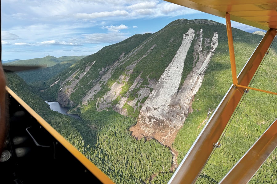
In July 2025, days of heavy rain triggered multiple mudslides and rockslides in New York State's Adirondacks, including this one on Mount Colden. It blocked access to hiking trails in a popular recreation spot in the High Peaks Wilderness area.
To this day, the scar where the landslide began is unmissable from miles away.
That this landslide didn’t get recorded is somewhat a quirk of disaster recovery. Debris from the slide itself wasn’t the singular cause of damage to any buildings or roads, so there was no financial fingerprint. The slide didn’t injure or kill anyone. Landslides aren’t mapped in the same way that the Federal Emergency Management Agency, for instance, tracks flood zones and inundation risk, and a rate of occurrence can’t be modeled like a flood. Because landslide insurance practically doesn’t exist in most of the country, no one needs the data to assess actuarial risk for homeowners. According to the New York Geological Survey, the vast majority of landslides in the state go unreported.
But the Shingle Kill landslide did change the mountainside that day. Joel DuBois, director of the Greene County Department of Soil and Water, visited the site in the days after Irene and reviewed some recent photos of the stream corridor that was affected by the debris flow. “There appear to be a number of cycles of incision and aggradation,” DuBois wrote. “That is to say that channel incision, or down-cutting, results in steeper bank angles and higher bank heights, leaving the adjacent hillsides susceptible to landslide” both during and after flood events. The sediment then flows downstream and accumulates at existing debris dams, which tends to cause channels to migrate laterally, he explained. That too can trigger landslide activity.
The area remains vulnerable at a time when landslide risk is expected to increase across much of the northeastern U.S.—as well as a lot of the world. That’s because climate change is causing concentrated bursts of rain that fall over a short period to occur more frequently. Such intense rainfall events are known to be the biggest trigger of landslides.
It’s not quite right to say landslides aren’t common in the Catskills, because this superold plateau has been eroding for perhaps a few hundred million years. On a nongeological timescale, though, landslide susceptibility isn’t something many people think about in New York State, and the state geological survey can estimate only that between 100 and 400 occur every year.
As warmer temperatures lead to more moisture in the air, climate change is quickly warping that math. In the Northeast, the heaviest rainstorms are now 60 percent heavier than they were in the 1950s, according to the Fifth National Climate Assessment. In a 2023 study, researchers at Dartmouth College found that extreme precipitation in the region will increase by 52 percent by the end of this century, mostly because of a higher number of such events each year. “Our landscape has pretty much been in equilibrium, for the most part, since the glaciers left,” Andrew Kozlowski, a New York State geologist, explained during a 2022 USGS presentation. “With climate change, we may be shifting that equilibrium and throwing all of this completely off balance, and there’s going to be a natural readjustment.”
“Landslide” is the broad term for the movement of soils, rocks, and other debris down a slope. There are several different classifications for landslides. Some, like the Shingle Kill debris flow, move far too fast to be outrun. More than any other factor, they are set off by an intense storm. Others, such as rotational slides—backward-curving masses of material that can be hundreds of feet deep—are more sensitive to rainfall over the course of a season. They can move very slowly when a destabilized slope takes months to fail.
Landslides can happen pretty much anywhere certain conditions exist but are most common in very steep mountain terrain where plenty of rain falls. In 2024 the U.S. Landslide Susceptibility Index was released and stated that 44 percent of the land in the U.S. could potentially experience landslide activity. Susceptibility is based partly on where landslides have occurred previously, and it wasn’t until the past decade that high-resolution lidar made it possible for states to survey vast swaths of land for evidence and clues. The extent to which states have done so is uneven.
Benjamin DeJong, director of the Vermont Geological Survey, says you can think of landslide susceptibility as an inexact recipe. You’re going to need steeper slopes to achieve some kind of baseload that puts weight on the slope. Next, add loose, unconsolidated materials that can become saturated with water. If those saturated materials are overlying or underlying another kind of material that has very different permeability, meaning its ability to take in water, that contrast is a big factor.
“By far the year that had the greatest total landslides that I’ve recorded was 2024. Last year was completely off the scale.” —David Petley University of Hull
Then you look at what’s on the base and on the top of the slope. If the base, or toe, is undercut—by a road, for instance, or a meandering stream—that’s going to make the slope more susceptible. Overloading the top, or head, of a slope with weight also drives it toward failure.
The fourth ingredient is the loss of vegetation that helps to hold soils together. In California, for example, this loss happens on a regular cycle with wildfires. Vermont, DeJong says, went through an experiment in the 1800s where “the state tried to turn itself into Scotland by cutting down all the trees and bringing in sheep.” It was a bad idea that caused erosion and mass slope failure everywhere. The state gave up on that plan and allowed the forests to regrow. The last variable is how the slope handles stormwater. With more extreme precipitation events, it doesn’t take much mismanagement of a slope for the heavy weight of rain to concentrate in ways that cause the slope to fail.
Geologist David Petley, who writes the Landslide Blog for the American Geophysical Union, has been maintaining a database of deadly landslides worldwide since 2004. He’s seen a clear long-term trend. “But by far—by far—the year that had the greatest total landslides that I’ve recorded was 2024,” he says. “Last year was completely off the scale.” Why? “The most simple hypothesis is that it was the year with the highest-ever global temperature. I do genuinely think it’s that simple.” There’s solid evidence that high atmospheric temperature, and possibly high sea-surface temperatures as well, drove high-precipitation events globally. “Last year I saw an extraordinary frequency of big storms that were triggering hundreds of thousands of landslides,” Petley says. They occurred at different locations all over the world.
In the U.S., the remnants of Hurricane Helene, which came ashore in Florida in September 2024, dumped between 20 and 30 inches of water over the mountains of North Carolina. The storm ended up triggering more than 2,000 landslides across the Southeast. According to the USGS, in some cases several smaller mudslides converged into a single channel, burying entire communities in debris. The total number of people killed by landslides specifically, versus by flooding or a combination of the two, is hard to parse. But one storm-triggered mudslide in Craigtown, N.C., swept through a house, killing 11 members of the Craig family for whom the town is named. During the storm, four successive landslides in that valley wiped out the town.
In the Appalachian Mountains of North Carolina, very old landslides might have been “brought back into activity” during Helene, Petley explains, reactivated by staggeringly intense rain. Scientists at World Weather Attribution pinned that extra intensity on climate change, reporting that it had made the storm’s rainfall throughout the Southeast about 10 percent heavier and the “unprecedented” rainfall totals over three days about 70 percent more likely than they would have been otherwise.
In California, where dramatic debris flows have long been a concern, climate change is making matters worse in two ways. Bigger, more destructive wildfires wipe out more of the vegetation that was stabilizing the landscape. And then atmospheric rivers—a newer phenomenon consisting of long, narrow conveyer belts of moisture—arrive, bringing a series of intense rainfall events. Between December 2022 and January 2023 nine back-to-back atmospheric rivers struck California, leading to more than 600 landslides.
Climate change is increasing landslide risk globally in other ways. In high mountain regions such as the European Alps and the Himalayas, melting permafrost and retreating glaciers are destabilizing steep slopes. A catastrophic glacier collapse in Switzerland this past summer destroyed an entire village; thankfully officials evacuated people just before it happened, but one person was killed.

A section of the Shingle Kill streambed 14 years after a debris flow occurred on Arizona Mountain in New York State's Catskills during intense rain. The southern slope, shown on the left, continues to erode.
Petley says the thing that’s surprised him most recently is the speed of change, especially during this past El Niño cycle. Strong rainfall events have always happened occasionally, but suddenly they are happening a lot. “I don’t think I fully understand why we’re seeing such a rapid shift to these events where a heavy rainfall will trigger 2,000 or 3,000 landslides in a relatively small area,” Petley says. In New Zealand in 2023, Cyclone Gabrielle triggered at least 100,000 landslides. Even in regions such as the Himalayas, where the monsoon season is becoming drier overall, the number of landslides is going up because the rainstorms that do arrive are more intense. “I worry a bit,” Petley says, “that the shift is happening so fast and becoming so extreme that in some places the risk is essentially unmanageable.”
Vermont, like New York State, got clobbered by Tropical Storm Irene in 2011. DeJong, the Vermont state geologist, describes Irene as a wake-up call. “The mountains,” he says with a degree of irony, “are now where hurricanes come to die.”
But it wasn’t until two freak July rainstorms—spaced exactly a year apart, one in 2023 and one in 2024—that the state’s geological survey became alarmed that landslides were going to be a much bigger problem than in the past. Given his experiences with Irene, DeJong expected the July 2023 storm to lead to maybe a handful of slides. Within a month of the storm his team had received more than 70 requests for landslide evaluations. Working on the ground in the aftermath of these two storms made DeJong realize that rainfall events at that scale “are fundamentally altering the landscape in ways that are not immediately recognizable,” he says.
Now the four-person Vermont Geological Survey team is working on putting together a landslide-susceptibility map. The goal is to start with a more technical tool for scientists that can be overlaid with forecasts from the National Weather Service, which would create debris-flow forecasts like the ones already produced by the Los Angeles Department of Public Works. If that’s successful, the next step, DeJong says, would be creating a map that’s more accessible to the public, something that a person who’s looking to buy a parcel of land could reference to do some due diligence on landslide risk.
But that gets tricky. The city of Juneau, Alaska, carried out a mapping project to evaluate levels of risk, with the aim of incorporating that risk into its land-use planning in 2024. The maps also would have highlighted concerns with existing buildings, though, meaning homeowners identified as living in high-risk areas might see their property values decline. Juneau’s susceptibility map was vehemently rejected by the community last year and was not adopted. In Vermont, as in many places, evidence of slope instability—and even past failures—hardly factors into development or the issuing of building permits.
Rising landslide risk in mountainous places also creates a difficult tension about how to adapt to the effects of climate change. Recent disasters have made clear that mountain valleys in certain regions may not be great places to live. In Vermont “we’re losing a lot of housing in our flood corridors—which is a good thing,” DeJong says. “We’re getting people out of harm’s way.” But the state, like many others around the country, has a housing crunch with the need to build more. “When we’ve lost options down in the valleys, that puts a lot of building pressure up onto our slopes,” he explains. “And it’s really hard to make the argument not to do that.” Successfully adapting to one climate effect means running headlong into another.
There are many climate-related problems to worry about in my Catskills community: the surging numbers of disease-carrying ticks, the choking out of native plants by invasive species, the hurricane-remnant floods, the decrease in winter snowfall that would replenish the aquifers, the summertime whiplash between deluge and drought. The Shingle Kill landslide wasn’t on my radar as a potential climate problem until a massive, ultraluxury resort and “branded residences” development was proposed for the hillside next to it. The plan calls for building more than 85 new structures totaling 275,593 square feet on a 102-acre site, 45 percent of which is classified as having steep slopes. To do so, developers will have to cut down about 11 acres of trees. The site, like the rest of our hamlet, has no access to municipal water or sewage. In addition to lining ponds for water storage and building a wastewater-treatment plant, a road network will be cut into the mountainside.
The public documents for the project do not appear to show that a geologist evaluated whether the weight of all that development, plus the deforestation and excavation during construction, might further destabilize the slopes of the Shingle Kill. Our town planning board approved the project in May 2025 without requiring an environmental impact statement that would have identified and attempted to mitigate the biggest hazards. (I am a member of a community group that is suing our town planning board, arguing it didn’t take a hard look at potentially significant adverse effects to the environment from this project, including on groundwater availability, erosion, flooding and landslide risk.)
Recent intense rain events “are fundamentally altering the landscape in ways that are not immediately recognizable.” —Benjamin DeJong Vermont Geological Survey
Diane and Ken Herchenroder’s house wasn’t damaged by the 2011 landslide, but the event did plenty of harm. Much of their property was rearranged by the acute displacement of raging water. The solid plug of rocks and mud, some 10 feet tall, had to be excavated from the streambed. Even once things were fixed, they didn’t want to stay. “We used to listen to the rain and the stream with the windows open, and it was very comforting,” Diane says from their house in New Hampshire, where they moved two years after the storm. “Honestly, after that slide occurred, Ken and I, I would have to say, have a little bit of post-traumatic stress from that.” Diane says her photographs of the landslide are on a CD somewhere; she hasn’t looked at them since. “I don’t really ever even talk about that day,” she says. “It was pretty devastating.”
In 2018 Joe Merlino bought the Herchenroders’ former property, where he now lives with his daughter and his mother. A few years ago they had members of the U.S. Army Corps of Engineers come assess ongoing erosion along the Shingle Kill. The streambed continues to widen, and a sharp curve just upstream of Merlino’s house means floodwaters could rush right at it. He recalls that in 2021, when Tropical Storm Henri came through the Catskills, boulders smashed against the bridge that provides access between his house and his mom’s trailer. “[The Army Corps] basically told us the erosion is not going to stop,” Merlino says.
Merlino often walks along the edges of the fan with his dog, observing the changes to the old debris piles with each storm. The possibility of more landslide activity is never far from his mind, he says, especially with a major development approved for the hillside above his home.
I asked him whether he gets scared every time there’s heavy rain. “I come home from work early,” he says, to keep an eye on things and intervene if necessary. A few years ago he moved his daughter’s bedroom to the front of the house, away from the steep pitch of his backyard. “My fear is about my living room, which is in the back and has a lot of glass,” he says. “I watch the water rip around that curve, and one day something is going to come through and take the side of my house right out.”
Greene County, where the Merlino family and I both live, is one of the four counties identified by New York State as the most vulnerable to expected annual building loss from landslides in the future. The county has steep escarpments that slope into the Hudson River Valley, which is rich in clays and silts from Glacial Lake Albany, a prehistoric waterbody that drained some 10,500 years ago. “I think we’re going to see a lot more slope failures in some of these populated areas in the Hudson Valley,” Kozlowski, the New York State geologist, said in 2022.
Greene County considered landslides a threat back in 2016. In 2023 the county revisited its hazard-mitigation plan; our town, Cairo, was the only municipality out of 19 that did not participate. In the updated plan, the county removed landslides as a hazard, reasoning that they are “unlikely to lead to a disaster.”
It’s true that landslides don’t do the same economic harm to our county as flooding and ice storms. But when they do occur, rebuilding is rarely an option. When a family lost their house in the town of Catskill to a landslide after a heavy rain event in May 2024, there wasn’t much anyone could do but condemn the structure.
With funding for emergency response and climate resilience endangered at the federal level, is it worth investing in susceptibility maps for landslides that may never occur? Should people hesitate to build on potentially unstable slopes when that’s perhaps less risky than living directly in a flood path?
DeJong says these are valid questions, but after his experiences over the past few years, he sees things differently. “We in Vermont have, so far, been incredibly fortunate to not see any fatalities,” he says. He remembers an older couple who were sitting in their house in July 2023 when the slope behind it failed. The structure warped outward, bending absurdly into something “that looked like a fun house falling over on them,” he recalls. Emergency services extracted them relatively unharmed, but DeJong knows it could have been worse. It turned out a lot worse in western North Carolina during Helene, where for years many building codes dismissed the risk of construction on steep slopes.
It might take only one bad slide to change people’s minds about the risk. Before 2014, DeJong says, Washington State, much like New England, did not pay much attention to landslides and had no landslide program in its state geological survey. But then a slope in Oso, about an hour outside Seattle, experienced a catastrophic failure, taking out a neighborhood and killing 43 people. The state now takes landslides very seriously.
“The Oso slide of New England could be right around the corner,” DeJong says. “People will say, ‘Why didn’t we know about this hazard? X number of people just died.’” He hopes his team can get its landslide-susceptibility maps finished so that when big rainfall events are forecast for the Green Mountains, officials can warn people in especially risky areas. “We’re really trying to switch to being more proactive so that X never becomes a number.”