
Fiery 5,000 MPH Winds: Webb Maps Weather on Extreme Exoplanet WASP-43 b
This artist’s concept shows what the hot gas-giant exoplanet WASP-43 b could look like. WASP-43 b is a Jupiter-sized planet circling a star roughly 280 light-years away, in the constellation Sextans. The planet orbits at a distance of about 1.3 million miles (0.014 astronomical units, or AU), completing one circuit in about 19.5 hours. Because it is so close to its star, WASP-43 b is probably tidally locked: its rotation rate and orbital period are the same, such that one side faces the star at all times. Credit: NASA, ESA, CSA, Ralf Crawford (STScI)WASP-43 b is cloudy on the nightside and clear on the dayside, with equatorial winds howling around the planet at 5,000 miles per hour.Sometimes not finding something is just as exciting and useful as finding it. Take hot Jupiter WASP-43 b, for example. This tidally locked world has a searing-hot, permanent dayside and a somewhat cooler nightside. Astronomers using Webb to map the temperature and analyze the atmosphere around the planet expected to detect methane, a common carbon molecule, on the nightside. But there is clearly no sign of it. Why? The result suggests that supersonic winds of hot gas are blowing around from the dayside, thoroughly churning up the atmosphere, and preventing the chemical reactions that would otherwise produce methane on the nightside.This light curve shows the change in brightness of the WASP-43 system over time as the planet orbits the star. This type of light curve is known as a phase curve because it includes the entire orbit, or all phases of the planet.Because it is tidally locked, different sides of WASP-43 b rotate into view as it orbits. The system appears brightest when the hot dayside is facing the telescope, just before and after the secondary eclipse when the planet passes behind the star. The system grows dimmer as the planet continues its orbits and the nightside rotates into view. After the transit when the planet passes in front of the star, blocking some of the starlight, the system brightens again as the dayside rotates back into view.Credit: NASA, ESA, CSA, Ralf Crawford (STScI), Taylor Bell (BAERI), Joanna Barstow (The Open University), Michael Roman (University of Leicester)Webb Space Telescope Maps Weather on Planet 280 Light-Years AwayAn international team of researchers has successfully used NASA’s James Webb Space Telescope to map the weather on the hot gas-giant exoplanet WASP-43 b.Precise brightness measurements over a broad spectrum of mid-infrared light, combined with 3D climate models and previous observations from other telescopes, suggest the presence of thick, high clouds covering the nightside, clear skies on the dayside, and equatorial winds upwards of 5,000 miles per hour mixing atmospheric gases around the planet. The investigation is just the latest demonstration of the exoplanet science now possible with Webb’s extraordinary ability to measure temperature variations and detect atmospheric gases trillions of miles away.Tidally Locked “Hot Jupiter”WASP-43 b is a “hot Jupiter” type of exoplanet: similar in size to Jupiter, made primarily of hydrogen and helium, and much hotter than any of the giant planets in our own solar system. Although its star is smaller and cooler than the Sun, WASP-43 b orbits at a distance of just 1.3 million miles – less than 1/25th the distance between Mercury and the Sun.With such a tight orbit, the planet is tidally locked, with one side continuously illuminated and the other in permanent darkness. Although the nightside never receives any direct radiation from the star, strong eastward winds transport heat around from the dayside.Since its discovery in 2011, WASP-43 b has been observed with numerous telescopes, including NASA’s Hubble and now-retired Spitzer space telescopes.“With Hubble, we could clearly see that there is water vapor on the dayside. Both Hubble and Spitzer suggested there might be clouds on the nightside,” explained Taylor Bell, researcher from the Bay Area Environmental Research Institute and lead author of a study published on April 30 in Nature Astronomy. “But we needed more precise measurements from Webb to really begin mapping the temperature, cloud cover, winds, and more detailed atmospheric composition all the way around the planet.”This simplified diagram of an exoplanet phase curve shows the change in total brightness of a star–planet system as the planet orbits the star. The system looks brighter when more of the lit side of the planet is facing the telescope (full phase). It looks dimmer when more of the dark side is facing the telescope (new phase), when the planet is blocking some of the starlight (transit), and when light from the planet is blocked by the star (secondary eclipse).(Top) Diagram showing the change in a planet’s phase (the amount of the lit side facing the telescope) as it orbits its star.(Bottom) Three-dimensional graph showing the change in the total brightness of the star–planet system as the planet orbits its star. In this graph, known as a light curve, the horizontal plane is orbital location and the vertical axis is brightness.(Right) Scale bar. In both the orbital diagram and the light curve, color indicates the observed brightness of the star + planet: from dark purple (less amount of light detected) to white (more light detected).Researchers use phase curves to study variations in reflectivity and temperature of a planet with longitude (from one side to another), which can provide insight into the surface composition and atmospheric conditions of the planet.Credit: NASA, ESA, CSA, Dani Player (STScI), Andi James (STScI), Greg Bacon (STScI)Mapping Temperature and Inferring WeatherAlthough WASP-43 b is too small, dim, and close to its star for a telescope to see directly, its short orbital period of just 19.5 hours makes it ideal for phase curve spectroscopy, a technique that involves measuring tiny changes in brightness of the star-planet system as the planet orbits the star.Since the amount of mid-infrared light given off by an object depends largely on how hot it is, the brightness data captured by Webb can then be used to calculate the planet’s temperature.The team used Webb’s MIRI (Mid-Infrared Instrument) to measure light from the WASP-43 system every 10 seconds for more than 24 hours. “By observing over an entire orbit, we were able to calculate the temperature of different sides of the planet as they rotate into view,” explained Bell. “From that, we could construct a rough map of temperature across the planet.”The measurements show that the dayside has an average temperature of nearly 2,300 degrees Fahrenheit (1,250 degrees Celsius) – hot enough to forge iron. Meanwhile, the nightside is significantly cooler at 1,100 degrees Fahrenheit (600 degrees Celsius). The data also helps locate the hottest spot on the planet (the “hotspot”), which is shifted slightly eastward from the point that receives the most stellar radiation, where the star is highest in the planet’s sky. This shift occurs because of supersonic winds, which move heated air eastward.“The fact that we can map temperature in this way is a real testament to Webb’s sensitivity and stability,” said Michael Roman, a co-author from the University of Leicester in the U.K.To interpret the map, the team used complex 3D atmospheric models like those used to understand weather and climate on Earth. The analysis shows that the nightside is probably covered in a thick, high layer of clouds that prevent some of the infrared light from escaping to space. As a result, the nightside – while very hot – looks dimmer and cooler than it would if there were no clouds.This set of maps shows the temperature of the visible side of the hot gas-giant exoplanet WASP-43 b, as the planet orbits its star. The temperatures were calculated based on more than 8,000 brightness measurements of 5- to 12-micron mid-infrared light detected from the star-planet system by MIRI (the Mid-Infrared Instrument) on NASA’s James Webb Space Telescope. In general, the hotter an object is, the more mid-infrared light it gives off. Credit: NASA, ESA, CSA, Ralf Crawford (STScI), Taylor Bell (BAERI), Joanna Barstow (The Open University), Michael Roman (University of Leicester)Missing Methane and High WindsThe broad spectrum of mid-infrared light captured by Webb also made it possible to measure the amount of water vapor (H2O) and methane (CH4) around the planet. “Webb has given us an opportunity to figure out exactly which molecules we’re seeing and put some limits on the abundances,” said Joanna Barstow, a co-author from the Open University in the U.K.The spectra show clear signs of water vapor on the nightside as well as the dayside of the planet, providing additional information about how thick the clouds are and how high they extend in the atmosphere.Surprisingly, the data also shows a distinct lack of methane anywhere in the atmosphere. Although the dayside is too hot for methane to exist (most of the carbon should be in the form of carbon monoxide), methane should be stable and detectable on the cooler nightside.“The fact that we don’t see methane tells us that WASP-43 b must have wind speeds reaching something like 5,000 miles per hour,” explained Barstow. “If winds move gas around from the dayside to the nightside and back again fast enough, there isn’t enough time for the expected chemical reactions to produce detectable amounts of methane on the nightside.”The team thinks that because of this wind-driven mixing, the atmospheric chemistry is the same all the way around the planet, which wasn’t apparent from past work with Hubble and Spitzer.Reference: “Nightside clouds and disequilibrium chemistry on the hot Jupiter WASP-43b” by Taylor J. Bell, Nicolas Crouzet, Patricio E. Cubillos, Laura Kreidberg, Anjali A. A. Piette, Michael T. Roman, Joanna K. Barstow, Jasmina Blecic, Ludmila Carone, Louis-Philippe Coulombe, Elsa Ducrot, Mark Hammond, João M. Mendonça, Julianne I. Moses, Vivien Parmentier, Kevin B. Stevenson, Lucas Teinturier, Michael Zhang, Natalie M. Batalha, Jacob L. Bean, Björn Benneke, Benjamin Charnay, Katy L. Chubb, Brice-Olivier Demory, Peter Gao, Elspeth K. H. Lee, Mercedes López-Morales, Giuseppe Morello, Emily Rauscher, David K. Sing, Xianyu Tan, Olivia Venot, Hannah R. Wakeford, Keshav Aggarwal, Eva-Maria Ahrer, Munazza K. Alam, Robin Baeyens, David Barrado, Claudio Caceres, Aarynn L. Carter, Sarah L. Casewell, Ryan C. Challener, Ian J. M. Crossfield, Leen Decin, Jean-Michel Désert, Ian Dobbs-Dixon, Achrène Dyrek, Néstor Espinoza, Adina D. Feinstein, Neale P. Gibson, Joseph Harrington, Christiane Helling, Renyu Hu, Nicolas Iro, Eliza M.-R. Kempton, Sarah Kendrew, Thaddeus D. Komacek, Jessica Krick, Pierre-Olivier Lagage, Jérémy Leconte, Monika Lendl, Neil T. Lewis, Joshua D. Lothringer, Isaac Malsky, Luigi Mancini, Megan Mansfield, Nathan J. Mayne, Thomas M. Evans-Soma, Karan Molaverdikhani, Nikolay K. Nikolov, Matthew C. Nixon, Enric Palle, Dominique J. M. Petit dit de la Roche, Caroline Piaulet, Diana Powell, Benjamin V. Rackham, Aaron D. Schneider, Maria E. Steinrueck, Jake Taylor, Luis Welbanks, Sergei N. Yurchenko, Xi Zhang and Sebastian Zieba, 30 April 2024, Nature Astronomy.DOI: 10.1038/s41550-024-02230-xThe MIRI observation of WASP-43 b was conducted as part of the Webb Early Release Science programs, which are providing researchers with a vast set of robust, open-access data for studying a wide array of cosmic phenomena.The James Webb Space Telescope is the world’s premier space science observatory. Webb is solving mysteries in our solar system, looking beyond to distant worlds around other stars, and probing the mysterious structures and origins of our universe and our place in it. Webb is an international program led by NASA with its partners, ESA (European Space Agency) and the Canadian Space Agency.
WASP-43 b is cloudy on the nightside and clear on the dayside, with equatorial winds howling around the planet at 5,000 miles per hour. Sometimes...
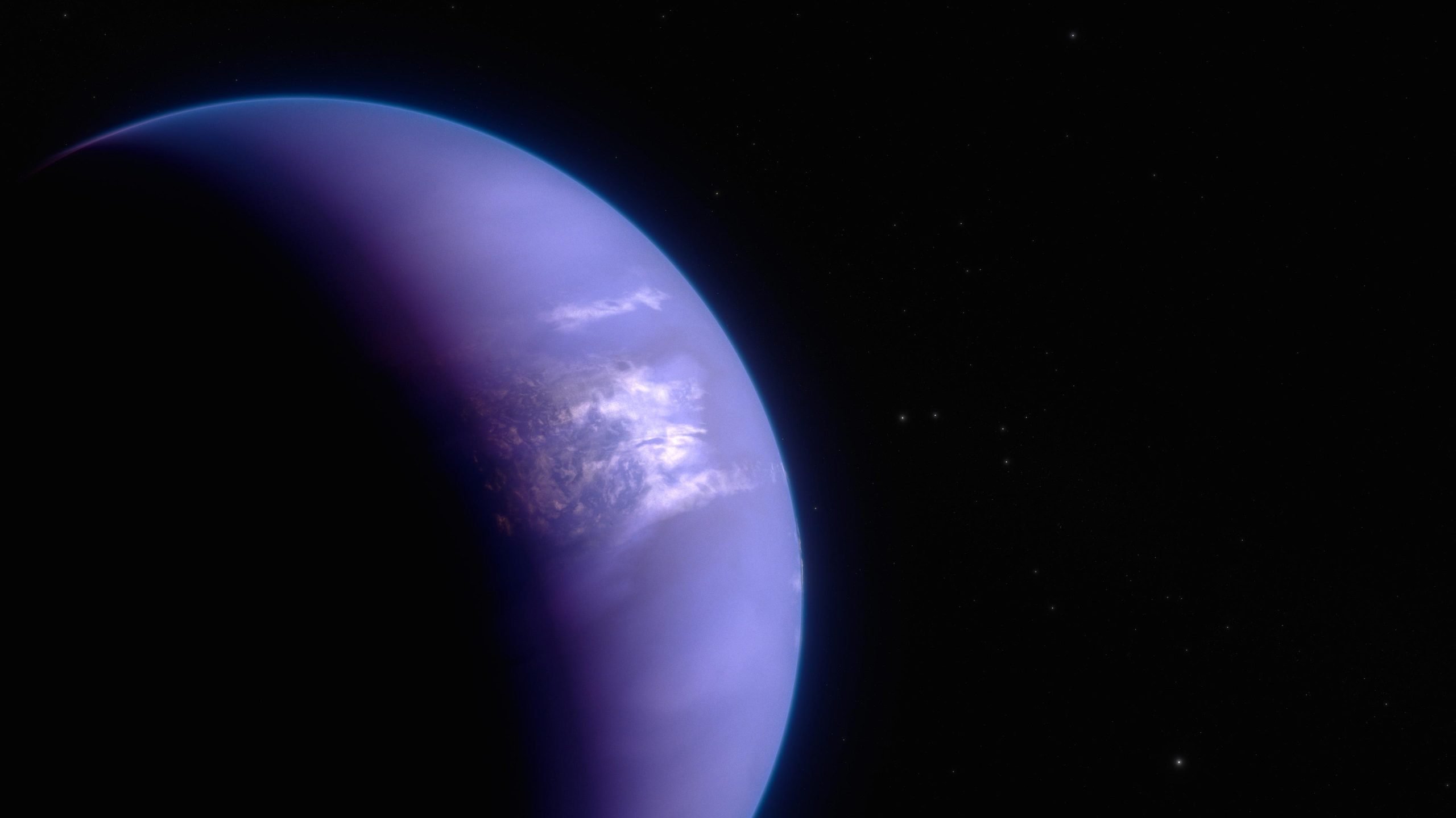
This artist’s concept shows what the hot gas-giant exoplanet WASP-43 b could look like. WASP-43 b is a Jupiter-sized planet circling a star roughly 280 light-years away, in the constellation Sextans. The planet orbits at a distance of about 1.3 million miles (0.014 astronomical units, or AU), completing one circuit in about 19.5 hours. Because it is so close to its star, WASP-43 b is probably tidally locked: its rotation rate and orbital period are the same, such that one side faces the star at all times. Credit: NASA, ESA, CSA, Ralf Crawford (STScI)
WASP-43 b is cloudy on the nightside and clear on the dayside, with equatorial winds howling around the planet at 5,000 miles per hour.
Sometimes not finding something is just as exciting and useful as finding it. Take hot Jupiter WASP-43 b, for example. This tidally locked world has a searing-hot, permanent dayside and a somewhat cooler nightside. Astronomers using Webb to map the temperature and analyze the atmosphere around the planet expected to detect methane, a common carbon molecule, on the nightside. But there is clearly no sign of it. Why? The result suggests that supersonic winds of hot gas are blowing around from the dayside, thoroughly churning up the atmosphere, and preventing the chemical reactions that would otherwise produce methane on the nightside.
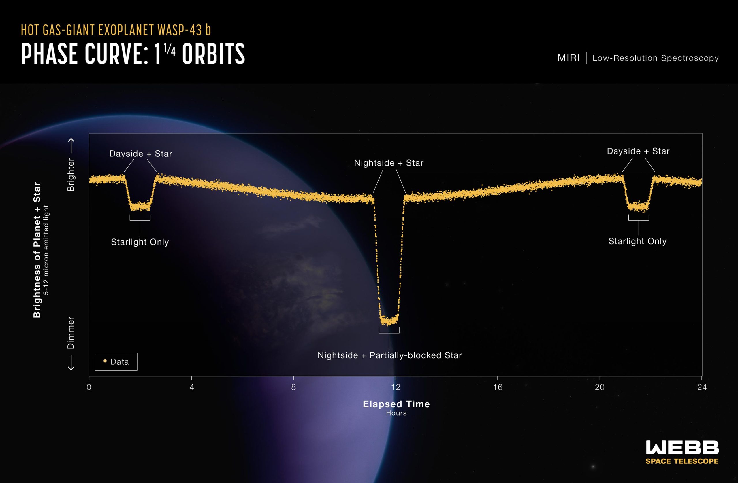
This light curve shows the change in brightness of the WASP-43 system over time as the planet orbits the star. This type of light curve is known as a phase curve because it includes the entire orbit, or all phases of the planet.
Because it is tidally locked, different sides of WASP-43 b rotate into view as it orbits. The system appears brightest when the hot dayside is facing the telescope, just before and after the secondary eclipse when the planet passes behind the star. The system grows dimmer as the planet continues its orbits and the nightside rotates into view. After the transit when the planet passes in front of the star, blocking some of the starlight, the system brightens again as the dayside rotates back into view.
Credit: NASA, ESA, CSA, Ralf Crawford (STScI), Taylor Bell (BAERI), Joanna Barstow (The Open University), Michael Roman (University of Leicester)
Webb Space Telescope Maps Weather on Planet 280 Light-Years Away
An international team of researchers has successfully used NASA’s James Webb Space Telescope to map the weather on the hot gas-giant exoplanet WASP-43 b.
Precise brightness measurements over a broad spectrum of mid-infrared light, combined with 3D climate models and previous observations from other telescopes, suggest the presence of thick, high clouds covering the nightside, clear skies on the dayside, and equatorial winds upwards of 5,000 miles per hour mixing atmospheric gases around the planet.
The investigation is just the latest demonstration of the exoplanet science now possible with Webb’s extraordinary ability to measure temperature variations and detect atmospheric gases trillions of miles away.
Tidally Locked “Hot Jupiter”
WASP-43 b is a “hot Jupiter” type of exoplanet: similar in size to Jupiter, made primarily of hydrogen and helium, and much hotter than any of the giant planets in our own solar system. Although its star is smaller and cooler than the Sun, WASP-43 b orbits at a distance of just 1.3 million miles – less than 1/25th the distance between Mercury and the Sun.
With such a tight orbit, the planet is tidally locked, with one side continuously illuminated and the other in permanent darkness. Although the nightside never receives any direct radiation from the star, strong eastward winds transport heat around from the dayside.
Since its discovery in 2011, WASP-43 b has been observed with numerous telescopes, including NASA’s Hubble and now-retired Spitzer space telescopes.
“With Hubble, we could clearly see that there is water vapor on the dayside. Both Hubble and Spitzer suggested there might be clouds on the nightside,” explained Taylor Bell, researcher from the Bay Area Environmental Research Institute and lead author of a study published on April 30 in Nature Astronomy. “But we needed more precise measurements from Webb to really begin mapping the temperature, cloud cover, winds, and more detailed atmospheric composition all the way around the planet.”
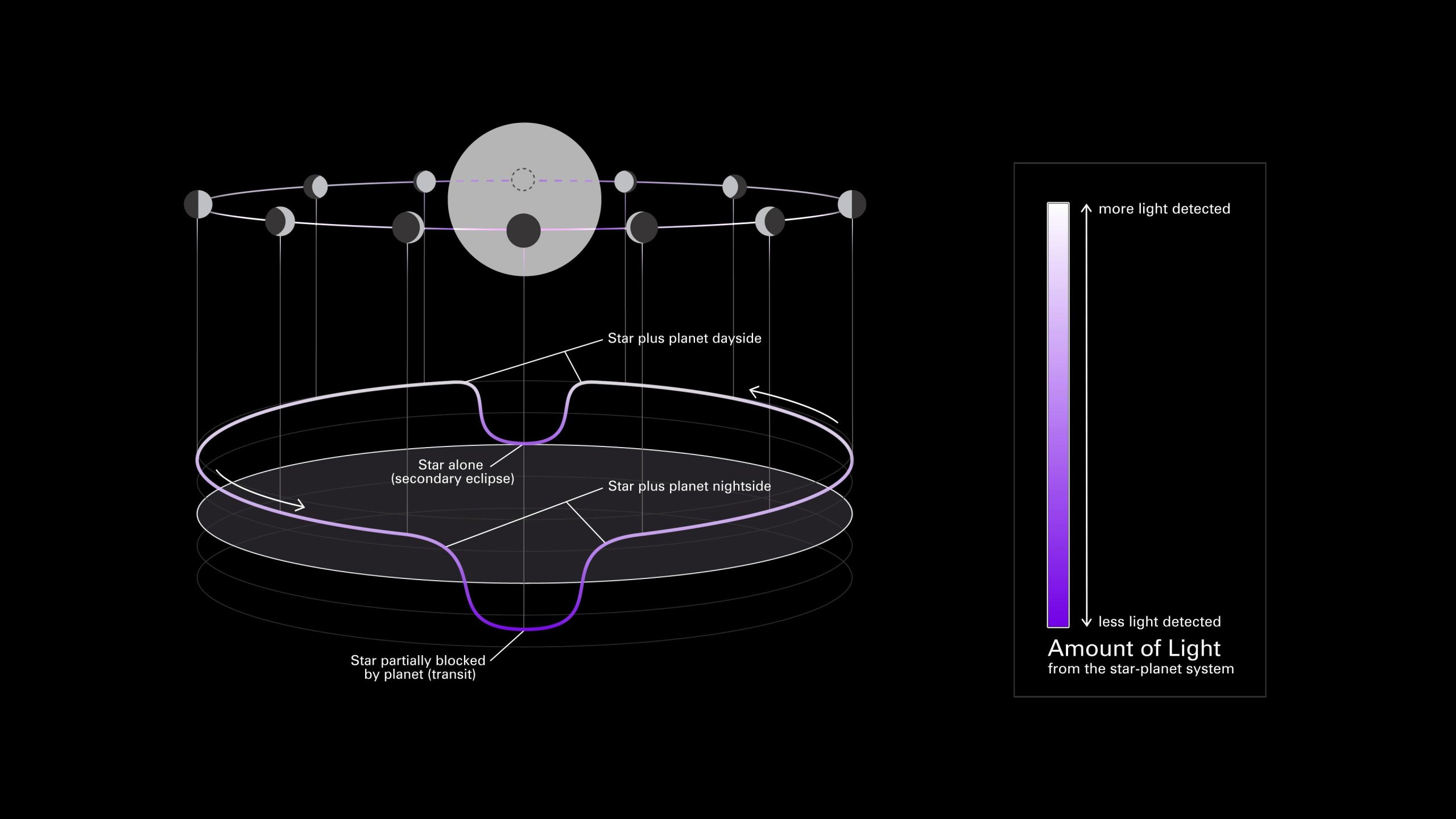
This simplified diagram of an exoplanet phase curve shows the change in total brightness of a star–planet system as the planet orbits the star. The system looks brighter when more of the lit side of the planet is facing the telescope (full phase). It looks dimmer when more of the dark side is facing the telescope (new phase), when the planet is blocking some of the starlight (transit), and when light from the planet is blocked by the star (secondary eclipse).
(Top) Diagram showing the change in a planet’s phase (the amount of the lit side facing the telescope) as it orbits its star.
(Bottom) Three-dimensional graph showing the change in the total brightness of the star–planet system as the planet orbits its star. In this graph, known as a light curve, the horizontal plane is orbital location and the vertical axis is brightness.
(Right) Scale bar. In both the orbital diagram and the light curve, color indicates the observed brightness of the star + planet: from dark purple (less amount of light detected) to white (more light detected).
Researchers use phase curves to study variations in reflectivity and temperature of a planet with longitude (from one side to another), which can provide insight into the surface composition and atmospheric conditions of the planet.
Credit: NASA, ESA, CSA, Dani Player (STScI), Andi James (STScI), Greg Bacon (STScI)
Mapping Temperature and Inferring Weather
Although WASP-43 b is too small, dim, and close to its star for a telescope to see directly, its short orbital period of just 19.5 hours makes it ideal for phase curve spectroscopy, a technique that involves measuring tiny changes in brightness of the star-planet system as the planet orbits the star.
Since the amount of mid-infrared light given off by an object depends largely on how hot it is, the brightness data captured by Webb can then be used to calculate the planet’s temperature.
The team used Webb’s MIRI (Mid-Infrared Instrument) to measure light from the WASP-43 system every 10 seconds for more than 24 hours. “By observing over an entire orbit, we were able to calculate the temperature of different sides of the planet as they rotate into view,” explained Bell. “From that, we could construct a rough map of temperature across the planet.”
The measurements show that the dayside has an average temperature of nearly 2,300 degrees Fahrenheit (1,250 degrees Celsius) – hot enough to forge iron. Meanwhile, the nightside is significantly cooler at 1,100 degrees Fahrenheit (600 degrees Celsius). The data also helps locate the hottest spot on the planet (the “hotspot”), which is shifted slightly eastward from the point that receives the most stellar radiation, where the star is highest in the planet’s sky. This shift occurs because of supersonic winds, which move heated air eastward.
“The fact that we can map temperature in this way is a real testament to Webb’s sensitivity and stability,” said Michael Roman, a co-author from the University of Leicester in the U.K.
To interpret the map, the team used complex 3D atmospheric models like those used to understand weather and climate on Earth. The analysis shows that the nightside is probably covered in a thick, high layer of clouds that prevent some of the infrared light from escaping to space. As a result, the nightside – while very hot – looks dimmer and cooler than it would if there were no clouds.
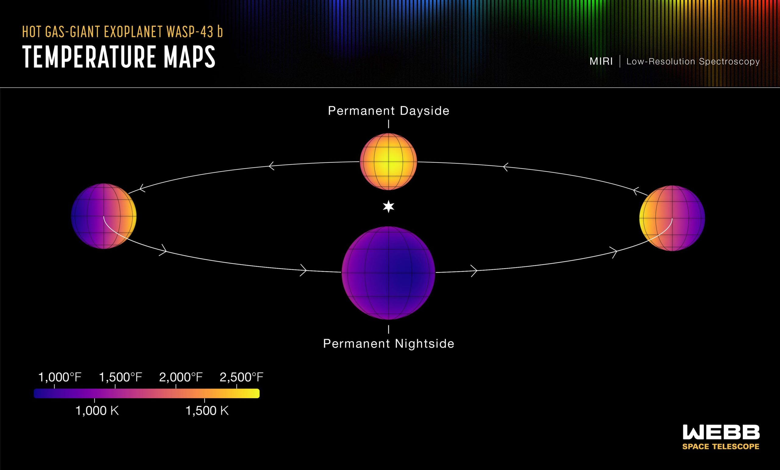
This set of maps shows the temperature of the visible side of the hot gas-giant exoplanet WASP-43 b, as the planet orbits its star. The temperatures were calculated based on more than 8,000 brightness measurements of 5- to 12-micron mid-infrared light detected from the star-planet system by MIRI (the Mid-Infrared Instrument) on NASA’s James Webb Space Telescope. In general, the hotter an object is, the more mid-infrared light it gives off. Credit: NASA, ESA, CSA, Ralf Crawford (STScI), Taylor Bell (BAERI), Joanna Barstow (The Open University), Michael Roman (University of Leicester)
Missing Methane and High Winds
The broad spectrum of mid-infrared light captured by Webb also made it possible to measure the amount of water vapor (H2O) and methane (CH4) around the planet. “Webb has given us an opportunity to figure out exactly which molecules we’re seeing and put some limits on the abundances,” said Joanna Barstow, a co-author from the Open University in the U.K.
The spectra show clear signs of water vapor on the nightside as well as the dayside of the planet, providing additional information about how thick the clouds are and how high they extend in the atmosphere.
Surprisingly, the data also shows a distinct lack of methane anywhere in the atmosphere. Although the dayside is too hot for methane to exist (most of the carbon should be in the form of carbon monoxide), methane should be stable and detectable on the cooler nightside.
“The fact that we don’t see methane tells us that WASP-43 b must have wind speeds reaching something like 5,000 miles per hour,” explained Barstow. “If winds move gas around from the dayside to the nightside and back again fast enough, there isn’t enough time for the expected chemical reactions to produce detectable amounts of methane on the nightside.”
The team thinks that because of this wind-driven mixing, the atmospheric chemistry is the same all the way around the planet, which wasn’t apparent from past work with Hubble and Spitzer.
Reference: “Nightside clouds and disequilibrium chemistry on the hot Jupiter WASP-43b” by Taylor J. Bell, Nicolas Crouzet, Patricio E. Cubillos, Laura Kreidberg, Anjali A. A. Piette, Michael T. Roman, Joanna K. Barstow, Jasmina Blecic, Ludmila Carone, Louis-Philippe Coulombe, Elsa Ducrot, Mark Hammond, João M. Mendonça, Julianne I. Moses, Vivien Parmentier, Kevin B. Stevenson, Lucas Teinturier, Michael Zhang, Natalie M. Batalha, Jacob L. Bean, Björn Benneke, Benjamin Charnay, Katy L. Chubb, Brice-Olivier Demory, Peter Gao, Elspeth K. H. Lee, Mercedes López-Morales, Giuseppe Morello, Emily Rauscher, David K. Sing, Xianyu Tan, Olivia Venot, Hannah R. Wakeford, Keshav Aggarwal, Eva-Maria Ahrer, Munazza K. Alam, Robin Baeyens, David Barrado, Claudio Caceres, Aarynn L. Carter, Sarah L. Casewell, Ryan C. Challener, Ian J. M. Crossfield, Leen Decin, Jean-Michel Désert, Ian Dobbs-Dixon, Achrène Dyrek, Néstor Espinoza, Adina D. Feinstein, Neale P. Gibson, Joseph Harrington, Christiane Helling, Renyu Hu, Nicolas Iro, Eliza M.-R. Kempton, Sarah Kendrew, Thaddeus D. Komacek, Jessica Krick, Pierre-Olivier Lagage, Jérémy Leconte, Monika Lendl, Neil T. Lewis, Joshua D. Lothringer, Isaac Malsky, Luigi Mancini, Megan Mansfield, Nathan J. Mayne, Thomas M. Evans-Soma, Karan Molaverdikhani, Nikolay K. Nikolov, Matthew C. Nixon, Enric Palle, Dominique J. M. Petit dit de la Roche, Caroline Piaulet, Diana Powell, Benjamin V. Rackham, Aaron D. Schneider, Maria E. Steinrueck, Jake Taylor, Luis Welbanks, Sergei N. Yurchenko, Xi Zhang and Sebastian Zieba, 30 April 2024, Nature Astronomy.
DOI: 10.1038/s41550-024-02230-x
The MIRI observation of WASP-43 b was conducted as part of the Webb Early Release Science programs, which are providing researchers with a vast set of robust, open-access data for studying a wide array of cosmic phenomena.
The James Webb Space Telescope is the world’s premier space science observatory. Webb is solving mysteries in our solar system, looking beyond to distant worlds around other stars, and probing the mysterious structures and origins of our universe and our place in it. Webb is an international program led by NASA with its partners, ESA (European Space Agency) and the Canadian Space Agency.