
Bioluminescence and Biodiversity: Insights From La Parguera’s Marine Ecosystem
Satellite image of La Parguera Natural Reserve captured on May 15, 2024, by the Operational Land Imager on Landsat 8.La Parguera in n Puerto Rico, corals, seagrass, and mangroves paint a colorful Caribbean scene by day, while the waters of a rare bioluminescent bay glow blue at night.Surfers may know the beaches in Puerto Rico’s north and northwest for their big swells and enticing breaks. But the vibe is different around the corner, along the island’s southwest coast. This spot tends to stay more protected from waves generated by trade winds and North Atlantic storms. Here, on a relatively broad, shallow shelf, the coral reefs at La Parguera are some of the most robust in Puerto Rico.Coral Reefs and MangrovesA group of fringing and patch reefs runs parallel to the shore. Mangrove trees, which appear dark green, line the coast and dot some of the coral islands. Seagrass beds extend offshore from the mangroves and on the lee side of linear reefs. Signs of these tropical marine ecosystems are visible in this image, acquired by the OLI (Operational Land Imager) on Landsat 8 on May 15, 2024. Protected Marine AreasThe area is protected within the La Parguera Natural Reserve, established in 1970 as the second marine protected area in Puerto Rico. The sheltered, shallow water supports reefs made of a mix of soft corals, such as sea fans, and stony ones, such as mustard hill corals. The varied habitat attracts a diverse assemblage of fish—along with snorkelers and divers.Credit: Priscila Vargas-Babilonia/USGSBioluminescence PhenomenonA small bay a few kilometers east of the town of La Parguera looks unremarkable during the day but is a rare and spectacular sight at night. Its waters glow blue due to the presence of a type of phytoplankton called dinoflagellates. These tiny bioluminescent organisms, supplied with nutrients from the surrounding mangroves, glow when the water is agitated because of a chemical reaction.Bioluminescence is common in the open ocean—it occurs in many creatures—but it is rare in near-shore environments. The dinoflagellates need an area of water protected from sudden swings in temperature, salinity, or turbidity. The sheltered spot in La Parguera is one of three bioluminescent bays in Puerto Rico and one of only five in the world.Environmental ChallengesLike many coastal areas around the world, La Parguera faces multiple environmental threats. When the water is too warm, for example, corals become susceptible to bleaching. This occurs when stressed corals expel the colorful algae that live inside them, and this can leave a reef at risk of starvation, disease, and even death. Significant bleaching events have harmed La Parguera’s reefs in the past, including a notable one in 2005, when the U.S. lost half of its coral reefs in the Caribbean.In addition, the rise in coastal development and deforestation have contributed to degraded water quality from increased sediment and nutrient input to the water. Major hurricanes, such as Maria in 2017, can also damage reefs and disturb the delicate chemistry of the bioluminescent bay.NASA’s OCEANOS ProgramLa Parguera and nearby Culebra are field sites of NASA’s OCEANOS program, which brings oceanography and marine field research opportunities to graduating high school seniors and first-generation undergraduate students in Puerto Rico.OCEANOS, which stands for Ocean Community Engagement and Awareness using NASA Earth Observations and Science for Hispanic/Latino Students, is a month-long summer internship program that trains participants in remote sensing image analysis and field techniques in ocean science. In addition to studying coral reef ecology and conservation, students build their own bio-optic field instruments, sample plankton, perform shore ecology studies, and replant coral reefs.NASA Earth Observatory image by Michala Garrison, using Landsat data from the U.S. Geological Survey.
La Parguera in n Puerto Rico, corals, seagrass, and mangroves paint a colorful Caribbean scene by day, while the waters of a rare bioluminescent bay...
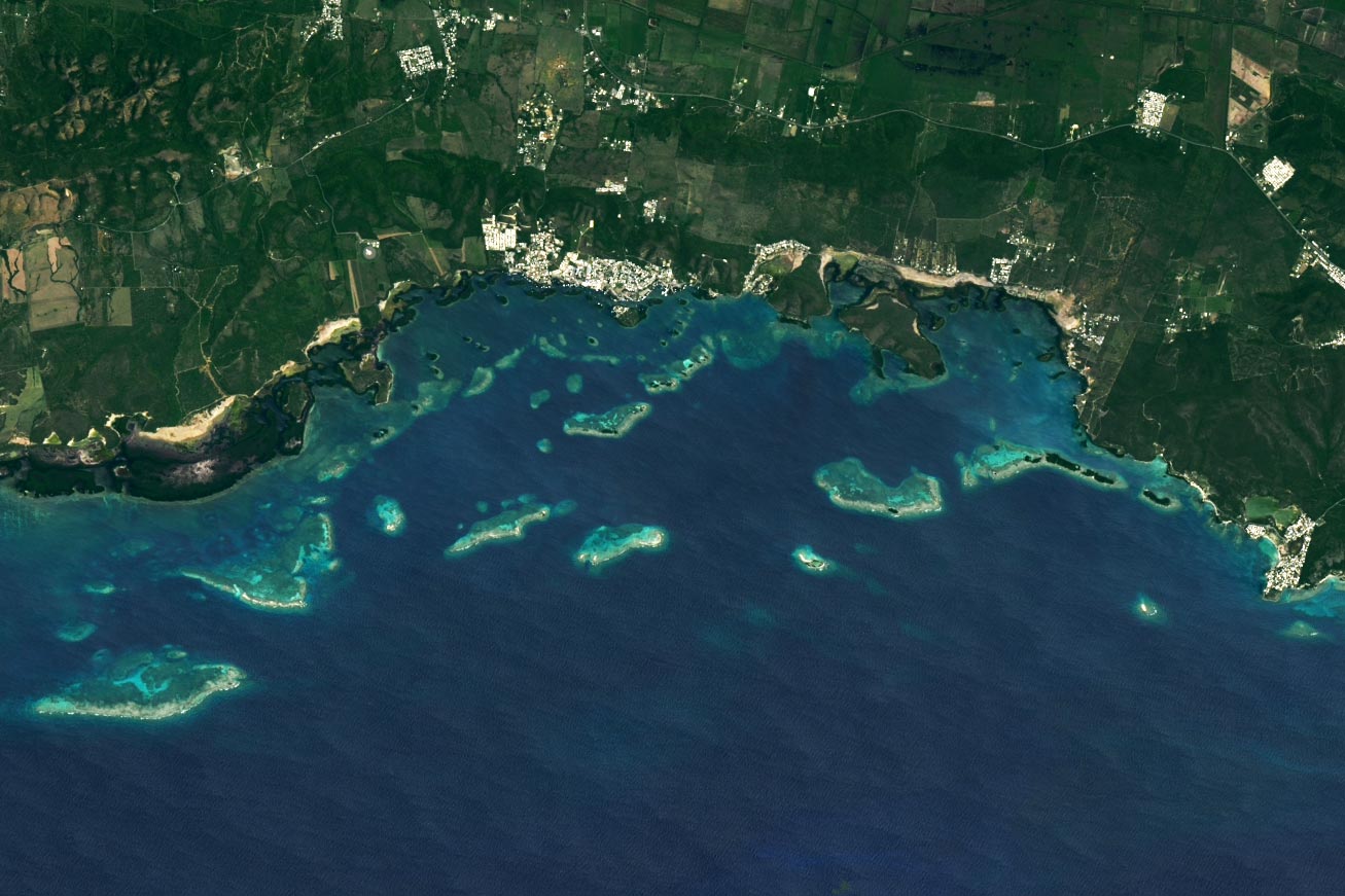
Satellite image of La Parguera Natural Reserve captured on May 15, 2024, by the Operational Land Imager on Landsat 8.
La Parguera in n Puerto Rico, corals, seagrass, and mangroves paint a colorful Caribbean scene by day, while the waters of a rare bioluminescent bay glow blue at night.
Surfers may know the beaches in Puerto Rico’s north and northwest for their big swells and enticing breaks. But the vibe is different around the corner, along the island’s southwest coast. This spot tends to stay more protected from waves generated by trade winds and North Atlantic storms. Here, on a relatively broad, shallow shelf, the coral reefs at La Parguera are some of the most robust in Puerto Rico.
Coral Reefs and Mangroves
A group of fringing and patch reefs runs parallel to the shore. Mangrove trees, which appear dark green, line the coast and dot some of the coral islands. Seagrass beds extend offshore from the mangroves and on the lee side of linear reefs. Signs of these tropical marine ecosystems are visible in this image, acquired by the OLI (Operational Land Imager) on Landsat 8 on May 15, 2024.
Protected Marine Areas
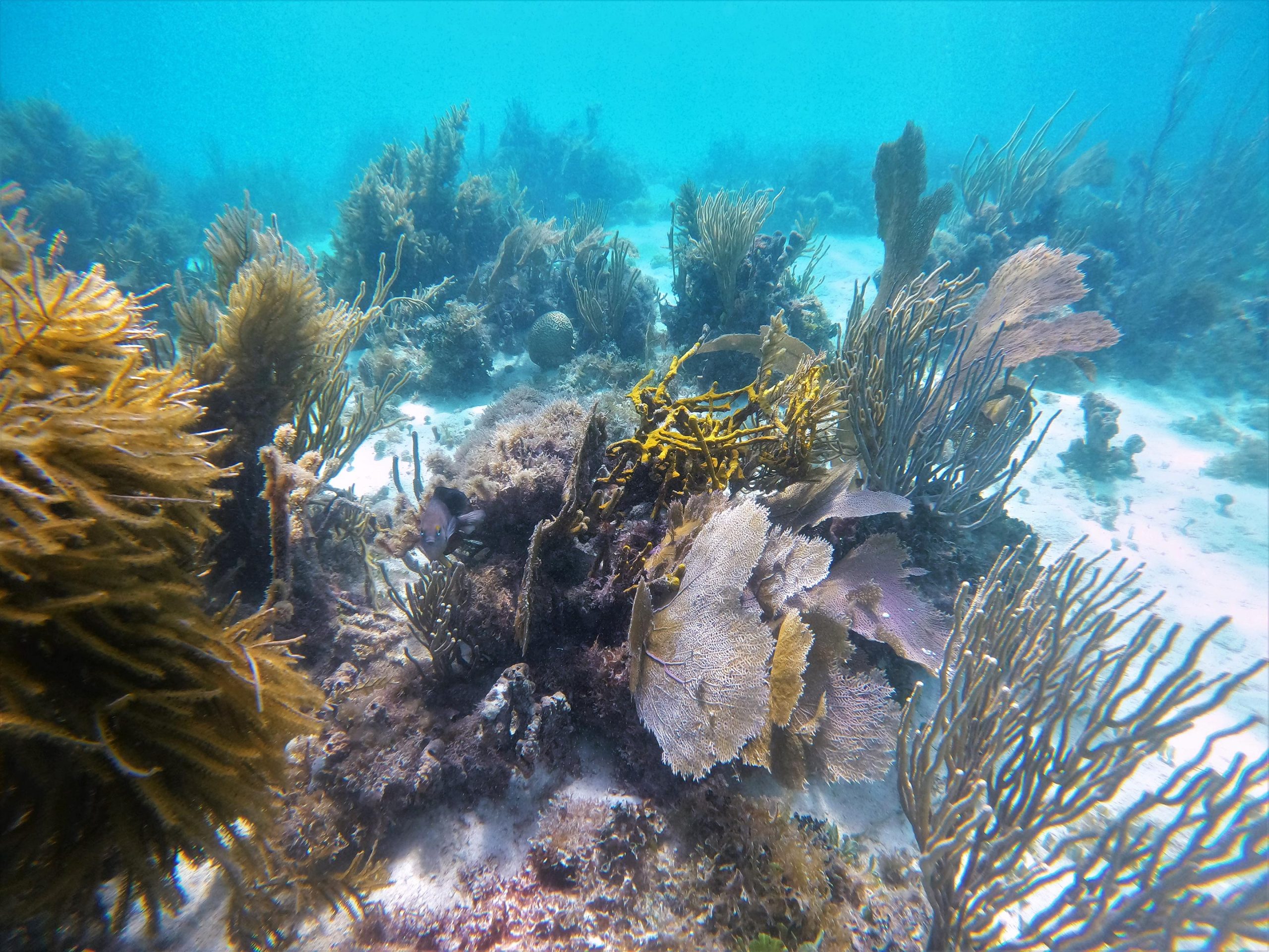
The area is protected within the La Parguera Natural Reserve, established in 1970 as the second marine protected area in Puerto Rico. The sheltered, shallow water supports reefs made of a mix of soft corals, such as sea fans, and stony ones, such as mustard hill corals. The varied habitat attracts a diverse assemblage of fish—along with snorkelers and divers.
Credit: Priscila Vargas-Babilonia/USGS
Bioluminescence Phenomenon
A small bay a few kilometers east of the town of La Parguera looks unremarkable during the day but is a rare and spectacular sight at night. Its waters glow blue due to the presence of a type of phytoplankton called dinoflagellates. These tiny bioluminescent organisms, supplied with nutrients from the surrounding mangroves, glow when the water is agitated because of a chemical reaction.
Bioluminescence is common in the open ocean—it occurs in many creatures—but it is rare in near-shore environments. The dinoflagellates need an area of water protected from sudden swings in temperature, salinity, or turbidity. The sheltered spot in La Parguera is one of three bioluminescent bays in Puerto Rico and one of only five in the world.
Environmental Challenges
Like many coastal areas around the world, La Parguera faces multiple environmental threats. When the water is too warm, for example, corals become susceptible to bleaching. This occurs when stressed corals expel the colorful algae that live inside them, and this can leave a reef at risk of starvation, disease, and even death. Significant bleaching events have harmed La Parguera’s reefs in the past, including a notable one in 2005, when the U.S. lost half of its coral reefs in the Caribbean.
In addition, the rise in coastal development and deforestation have contributed to degraded water quality from increased sediment and nutrient input to the water. Major hurricanes, such as Maria in 2017, can also damage reefs and disturb the delicate chemistry of the bioluminescent bay.
NASA’s OCEANOS Program
La Parguera and nearby Culebra are field sites of NASA’s OCEANOS program, which brings oceanography and marine field research opportunities to graduating high school seniors and first-generation undergraduate students in Puerto Rico.
OCEANOS, which stands for Ocean Community Engagement and Awareness using NASA Earth Observations and Science for Hispanic/Latino Students, is a month-long summer internship program that trains participants in remote sensing image analysis and field techniques in ocean science. In addition to studying coral reef ecology and conservation, students build their own bio-optic field instruments, sample plankton, perform shore ecology studies, and replant coral reefs.
NASA Earth Observatory image by Michala Garrison, using Landsat data from the U.S. Geological Survey.